IMAGES TAKEN NEAR TO
Oak Grange Road, GUILDFORD, GU4 7TZ
Introduction
This page details the photographs taken nearby to Oak Grange Road, GU4 7TZ by members of the Geograph project.
The Geograph project started in 2005 with the aim of publishing, organising and preserving representative images for every square kilometre of Great Britain, Ireland and the Isle of Man.

There are currently over 7.5m images from over14,400 individuals and you can help contribute to the project by visiting https://www.geograph.org.uk
Image Map
Images are licensed for reuse under creativecommons.org/licenses/by-sa/2.0
Notes
- Clicking on the map will re-center to the selected point.
- The higher the marker number, the further away the image location is from the centre of the postcode.
Image Listing (6 Images Found)
Images are licensed for reuse under creativecommons.org/licenses/by-sa/2.0
Image
Details
Distance
1
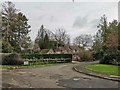
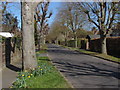
End of Lime Grove and Junction with Woodstock
Detached properties in street.
Image: © James Emmans
Taken: 12 Jan 2019
0.10 miles
2
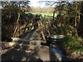
Footbridge, West Clandon
The footbridge over a drain on the footpath from Ripley Road to Lime Grove, West Clandon.
Image: © Alan Hunt
Taken: 1 Apr 2012
0.18 miles
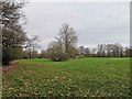
4
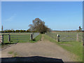
West Clandon
The footpath that runs north from Lime Grove with horse paddocks on either side
Image: © Alan Hunt
Taken: 1 Apr 2012
0.23 miles
5
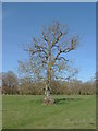
Fields near West Clandon
An oak tree in the fields to the west of Ripley Road
Image: © Alan Hunt
Taken: 1 Apr 2012
0.24 miles