IMAGES TAKEN NEAR TO
High Clandon, GUILDFORD, GU4 7RP
Introduction
This page details the photographs taken nearby to High Clandon, GU4 7RP by members of the Geograph project.
The Geograph project started in 2005 with the aim of publishing, organising and preserving representative images for every square kilometre of Great Britain, Ireland and the Isle of Man.

There are currently over 7.5m images from over14,400 individuals and you can help contribute to the project by visiting https://www.geograph.org.uk
Image Map
Images are licensed for reuse under creativecommons.org/licenses/by-sa/2.0
Notes
- Clicking on the map will re-center to the selected point.
- The higher the marker number, the further away the image location is from the centre of the postcode.
Image Listing (4 Images Found)
Images are licensed for reuse under creativecommons.org/licenses/by-sa/2.0
Image
Details
Distance
1
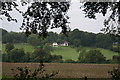
High Clandon Farm from Fullers Farm Road
Image: © Hugh Craddock
Taken: 28 Sep 2013
0.08 miles
2
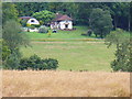
High Clandon Farm
On the dip slope of the North Downs - a mix of woodland, farm, grassland and cereal crops.
Image: © Colin Smith
Taken: 3 Aug 2008
0.08 miles
3
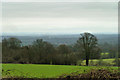
View from Staple Lane
Staple Lane has good views over the London basin, although visibility on this dull damp January day could be better.
Image: © Robin Webster
Taken: 25 Jan 2012
0.17 miles
4
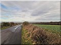
Clandon Downs
Northern view on Staple Lane.
Image: © James Emmans
Taken: 13 Jan 2019
0.25 miles