IMAGES TAKEN NEAR TO
Woking Road, GUILDFORD, GU4 7QS
Introduction
This page details the photographs taken nearby to Woking Road, GU4 7QS by members of the Geograph project.
The Geograph project started in 2005 with the aim of publishing, organising and preserving representative images for every square kilometre of Great Britain, Ireland and the Isle of Man.

There are currently over 7.5m images from over14,400 individuals and you can help contribute to the project by visiting https://www.geograph.org.uk
Image Map
Images are licensed for reuse under creativecommons.org/licenses/by-sa/2.0
Notes
- Clicking on the map will re-center to the selected point.
- The higher the marker number, the further away the image location is from the centre of the postcode.
Image Listing (29 Images Found)
Images are licensed for reuse under creativecommons.org/licenses/by-sa/2.0
Image
Details
Distance
1
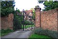
Burpham Court House
A little-known house which hides well behind its walls. Even Pevsner, in his Buildings of England, managed to miss it! The north wing retains one bay of a c1500 house. The south wing (seen above) was built in the late 16th century with a later chimney. The part between the two wings was rebuilt in the early 17th century.
Image: © Ron Strutt
Taken: 14 Sep 2005
0.03 miles
2
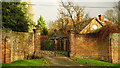
House at Jacobs Well
Complete with double rainbow.
Image: © Peter Trimming
Taken: 8 Dec 2015
0.05 miles
3
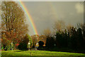
Gold in Jacobs Well
The end of the rainbow seems to be near to the centre of the village. Seen from the junction of Guildford Road (A320) and Clay Lane.
Image: © Peter Trimming
Taken: 8 Dec 2015
0.08 miles
4
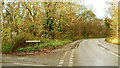
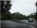
Burdenshott Road
At the junction with Guildford Road (A320).
Image: © Peter Trimming
Taken: 8 Dec 2015
0.12 miles
5
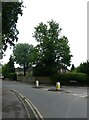
F.G.Barnes to L.I.Brary (13)
The northern end of the residential part of Woking Road
Image: © Basher Eyre
Taken: 26 Jul 2021
0.12 miles
6
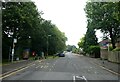
F.G.Barnes to L.I.Brary (14)
Looking south-southeast along Woking Road
Image: © Basher Eyre
Taken: 26 Jul 2021
0.13 miles
7
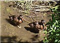
Paddling Ducks
Two ducks making their way upstream to Britten's Pond in northern Guildford.
Image: © Colin Smith
Taken: 24 Jul 2012
0.15 miles
8
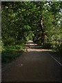
Britten's Pond, northeast corner
The path around the northeast corner of the fishing lake with the fields beyond.
Image: © Alan Hunt
Taken: 6 Jan 2015
0.15 miles
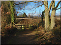
10
Britten's Pond
The path that runs down the east end of the lake.
Image: © Alan Hunt
Taken: 8 Jul 2010
0.16 miles