IMAGES TAKEN NEAR TO
Tynley Grove, GUILDFORD, GU4 7PE
Introduction
This page details the photographs taken nearby to Tynley Grove, GU4 7PE by members of the Geograph project.
The Geograph project started in 2005 with the aim of publishing, organising and preserving representative images for every square kilometre of Great Britain, Ireland and the Isle of Man.

There are currently over 7.5m images from over14,400 individuals and you can help contribute to the project by visiting https://www.geograph.org.uk
Image Map
Images are licensed for reuse under creativecommons.org/licenses/by-sa/2.0
Notes
- Clicking on the map will re-center to the selected point.
- The higher the marker number, the further away the image location is from the centre of the postcode.
Image Listing (35 Images Found)
Images are licensed for reuse under creativecommons.org/licenses/by-sa/2.0
Image
Details
Distance
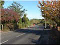
1
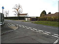
Holly Lea at the junction of Clay Lane
Image: © David Howard
Taken: 14 Feb 2016
0.05 miles
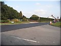
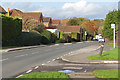
3
Jacob's Well
The junction of Jacob's Well Road with Clay Lane.
Image: © Alan Hunt
Taken: 6 Nov 2012
0.11 miles
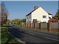
4
Clay Lane at the junction of Jacobs Well Road
Image: © David Howard
Taken: 7 Sep 2014
0.13 miles
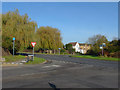
5
Jacob's Well Road
A residential road in Jacob's Well, a village on the outskirts of Guildford.
Image: © Alan Hunt
Taken: 6 Nov 2012
0.13 miles
6
Jacob's Well Road
Looking east from the entrance to the community centre.
Image: © Alan Hunt
Taken: 20 Nov 2015
0.16 miles
7
Burpham Cottages
The view along Clay Lane with Burpham Cottages on the right.
Image: © Alan Hunt
Taken: 6 Nov 2012
0.17 miles
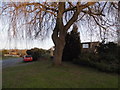
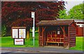
8
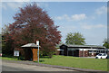
Bus Stop by the Village Hall
A nice copper beech just coming into leaf outside Jacobs Well village hall.
Image: © Des Blenkinsopp
Taken: 3 May 2023
0.17 miles
9
Notice board, bus stop and bus shelter, Jacobs Well Road, Jacobs Well
The notice board has the name of Worplesdon Parish Council on it, as Jscobs Well is part of that parish. Behind is Jacobs Well Village Hall.
Image: © P L Chadwick
Taken: 23 May 2012
0.17 miles
10
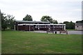
Village Hall at Jacobs Well
Jacobs Well was originally a small settlement around the junction of Clay Lane and the road to Sutton Green, not far from the River Wey. Today suburban bungalows and cul-de-sacs have sprung up and it is virtually on the outskirts of Guildford. In the fields close to the village can be seen the remains of a remarkable irrigation system developed by Sir Richard Weston in the first half of the 17th century. This led to the construction of the Wey Navigation, which is now owned by the National Trust.
Image: © Ron Strutt
Taken: 13 Sep 2005
0.18 miles