IMAGES TAKEN NEAR TO
Mallow Crescent, GUILDFORD, GU4 7GB
Introduction
This page details the photographs taken nearby to Mallow Crescent, GU4 7GB by members of the Geograph project.
The Geograph project started in 2005 with the aim of publishing, organising and preserving representative images for every square kilometre of Great Britain, Ireland and the Isle of Man.

There are currently over 7.5m images from over14,400 individuals and you can help contribute to the project by visiting https://www.geograph.org.uk
Image Map
Images are licensed for reuse under creativecommons.org/licenses/by-sa/2.0
Notes
- Clicking on the map will re-center to the selected point.
- The higher the marker number, the further away the image location is from the centre of the postcode.
Image Listing (46 Images Found)
Images are licensed for reuse under creativecommons.org/licenses/by-sa/2.0
Image
Details
Distance
1
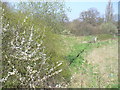
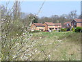
Spring Line at Spring Time
The straight-lined ditch in the middle of the photograph contains an emergent spring. This is at ca 50 metres (165 feet) a.s.l. on the dip slope of the North Downs. The spring flows through a culvert under the Guildford - Cobham railway line in the background.
Image: © Colin Smith
Taken: 2 Apr 2007
0.12 miles
2
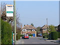
Glendale Drive, Burpham
Taken from its junction with New Inn Lane. Burpham is a large and well-to-do residential area in Guildford's eastern suburbs.
Image: © Colin Smith
Taken: 2 Apr 2007
0.14 miles
3
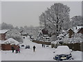
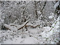
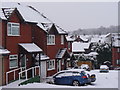
Hareward Road
Part of the circular main road running through Merrow Park, a 1980s residential estate. The two cars nearest camera looks like they have been abandoned in the snow!
Image: © Colin Smith
Taken: 2 Feb 2009
0.14 miles
4
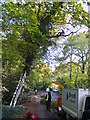
Tree Surgeons at Work
Traffic control in Guildford's New Inn Lane while branches are lopped above the road. The surgeon is on a branch above the van and is fastened to a variety of ropes.
Image: © Colin Smith
Taken: 31 Oct 2007
0.14 miles
5
Wells Road, Merrow Park
Wells Road is seen across a grassy bowl containing the spring line in this Guildford housing estate.
Image: © Colin Smith
Taken: 2 Apr 2007
0.15 miles
6
Merrow Common
A small area of dense deciduous woodland between Burpham and Merrow. It also has a dense network of narrow footpaths.
Image: © Colin Smith
Taken: 2 Feb 2009
0.16 miles
7
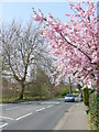
New Inn Lane, Burpham
This is a busy residential road in Guildford's eastern suburbs, connecting Burpham with Merrow.
Image: © Colin Smith
Taken: 2 Apr 2007
0.16 miles
8
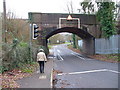
Merrow Railway Bridge
This low and narrow brick arch is regularly hit by tall lorries. Note the white lines channelling these vehicles into the middle of the road. A railway station in Merrow has often been planned. This would be left, off photograph, in the local Merrow Business Park. However, local opposition has prevented the building of it so far. Housing contractors have offered to build the station free in return for being allowed to develop adjacent agricultural land. The road is a "rat run" between Burpham and Merrow and is unusually empty in the photograph.
Image: © Colin Smith
Taken: 1 Jan 2007
0.16 miles
9
Tychbourne Drive
Suburban housing in eastern Guildford on a day when most workers and school children were snowbound.
Image: © Colin Smith
Taken: 6 Jan 2010
0.16 miles
10
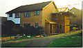
Merrow Park.
A large, 1980s housing estate on the eastern edge of Guildford - undergoing building works.
Image: © Colin Smith
Taken: Unknown
0.17 miles