IMAGES TAKEN NEAR TO
Fieldfare Avenue, YATELEY, GU46 6PD
Introduction
This page details the photographs taken nearby to Fieldfare Avenue, GU46 6PD by members of the Geograph project.
The Geograph project started in 2005 with the aim of publishing, organising and preserving representative images for every square kilometre of Great Britain, Ireland and the Isle of Man.

There are currently over 7.5m images from over14,400 individuals and you can help contribute to the project by visiting https://www.geograph.org.uk
Image Map
Images are licensed for reuse under creativecommons.org/licenses/by-sa/2.0
Notes
- Clicking on the map will re-center to the selected point.
- The higher the marker number, the further away the image location is from the centre of the postcode.
Image Listing (11 Images Found)
Images are licensed for reuse under creativecommons.org/licenses/by-sa/2.0
Image
Details
Distance
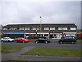
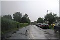
2
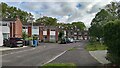
The edge of Yateley
The view across to the "village" from Love Lane. Yateley has undergone much expansion in recent decades.
Image: © Andrew Smith
Taken: 18 Feb 2006
0.13 miles
5
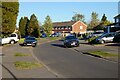
Partridge Avenue, Yateley
The roads here are named on an ornithological theme.
Image: © Andrew Smith
Taken: 22 Apr 2021
0.16 miles
7
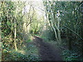
Green Lane
This end of Green Lane is just a bridleway.
Image: © Diane Sambrook
Taken: 16 Feb 2008
0.19 miles
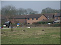
9
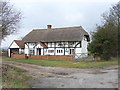
Firgrove Farm Cottage, Yateley
Situated at the northern end of Love Lane (byway).
Image: © Andrew Smith
Taken: 18 Feb 2006
0.24 miles