IMAGES TAKEN NEAR TO
Manor Park Drive, YATELEY, GU46 6JH
Introduction
This page details the photographs taken nearby to Manor Park Drive, GU46 6JH by members of the Geograph project.
The Geograph project started in 2005 with the aim of publishing, organising and preserving representative images for every square kilometre of Great Britain, Ireland and the Isle of Man.

There are currently over 7.5m images from over14,400 individuals and you can help contribute to the project by visiting https://www.geograph.org.uk
Image Map
Images are licensed for reuse under creativecommons.org/licenses/by-sa/2.0
Notes
- Clicking on the map will re-center to the selected point.
- The higher the marker number, the further away the image location is from the centre of the postcode.
Image Listing (8 Images Found)
Images are licensed for reuse under creativecommons.org/licenses/by-sa/2.0
Image
Details
Distance
1
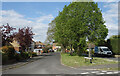
2016: a year on Geograph (Day 314)
Looking from Lower Moor into Maple Gardens
Image: © Basher Eyre
Taken: 9 Nov 2016
0.07 miles
2
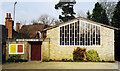
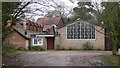
Yateley Baptist Church
Built in 1865 replacing the Zoar Chapel.
Image: © Michael FORD
Taken: Unknown
0.22 miles
4
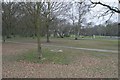
Yateley
A view across Yateley Green in the northwest part of the square. The remainder of the square is mostly housing.
Image: © Brendan and Ruth McCartney
Taken: Unknown
0.23 miles
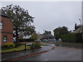
5
Rosary Gardens, Yateley
A cul de sac of houses around a small central green.
Image: © Des Blenkinsopp
Taken: 26 Apr 2022
0.24 miles
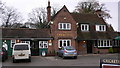
7
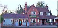
Cricketers Public House, Yateley
The Cricketers Public House at Yateley.
Image: © Len Williams
Taken: 26 Mar 2015
0.24 miles
8
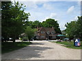
The Cricketers, Cricket Hill
A quiet setting for this pub on the edge of Yateley.
Image: © don cload
Taken: 9 May 2009
0.24 miles