IMAGES TAKEN NEAR TO
Hangerfield Close, YATELEY, GU46 6HR
Introduction
This page details the photographs taken nearby to Hangerfield Close, GU46 6HR by members of the Geograph project.
The Geograph project started in 2005 with the aim of publishing, organising and preserving representative images for every square kilometre of Great Britain, Ireland and the Isle of Man.

There are currently over 7.5m images from over14,400 individuals and you can help contribute to the project by visiting https://www.geograph.org.uk
Image Map (Loading...)


Getting Data...Please wait
Leaflet Map data © OpenStreetMap
Images are licensed for reuse under creativecommons.org/licenses/by-sa/2.0
Notes
- Clicking on the map will re-center to the selected point.
- The higher the marker number, the further away the image location is from the centre of the postcode.
Image Listing (6 Images Found)
Images are licensed for reuse under creativecommons.org/licenses/by-sa/2.0
Image
Details
Distance

2
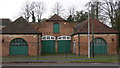
Buildings in Yateley
These buildings are in Hall Lane, opposite Home Park Road. They look as if they are buildings of a former large estate.
Image: © Shazz
Taken: 14 Dec 2009
0.21 miles
3
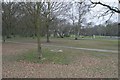
Yateley
A view across Yateley Green in the northwest part of the square. The remainder of the square is mostly housing.
Image: © Brendan and Ruth McCartney
Taken: Unknown
0.22 miles
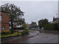
4
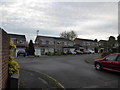
2016: a year on Geograph (Day 292)
Dungells Farm Close, Yateley
Image: © Basher Eyre
Taken: 18 Oct 2016
0.24 miles
5
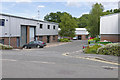
Aragon Road, Yateley
A side road off Aragon Road in the Blackbushe Business Park.
Image: © Alan Hunt
Taken: 18 Jul 2015
0.25 miles
6
2016: a year on Geograph (Day 314)
Looking from Lower Moor into Maple Gardens
Image: © Basher Eyre
Taken: 9 Nov 2016
0.25 miles