IMAGES TAKEN NEAR TO
Hall Lane, YATELEY, GU46 6HP
Introduction
This page details the photographs taken nearby to Hall Lane, GU46 6HP by members of the Geograph project.
The Geograph project started in 2005 with the aim of publishing, organising and preserving representative images for every square kilometre of Great Britain, Ireland and the Isle of Man.

There are currently over 7.5m images from over14,400 individuals and you can help contribute to the project by visiting https://www.geograph.org.uk
Image Map
Images are licensed for reuse under creativecommons.org/licenses/by-sa/2.0
Notes
- Clicking on the map will re-center to the selected point.
- The higher the marker number, the further away the image location is from the centre of the postcode.
Image Listing (7 Images Found)
Images are licensed for reuse under creativecommons.org/licenses/by-sa/2.0
Image
Details
Distance
1
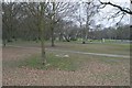
Yateley
A view across Yateley Green in the northwest part of the square. The remainder of the square is mostly housing.
Image: © Brendan and Ruth McCartney
Taken: Unknown
0.06 miles
2
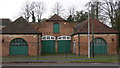
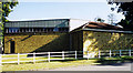
Buildings in Yateley
These buildings are in Hall Lane, opposite Home Park Road. They look as if they are buildings of a former large estate.
Image: © Shazz
Taken: 14 Dec 2009
0.06 miles

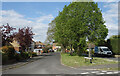
4
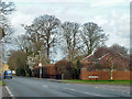
Hall Lane at Home Park Road junction
Just to be awkward, the bus stop is called Firgrove Road, which is further along on the left.
Image: © Robin Webster
Taken: 6 Mar 2014
0.09 miles
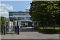
5
St Swithun, Yateley
Modern Roman Catholic Church built in 1969.
Image: © Michael FORD
Taken: Unknown
0.15 miles
6
Rosary Gardens, Yateley
A cul de sac of houses around a small central green.
Image: © Des Blenkinsopp
Taken: 26 Apr 2022
0.18 miles