IMAGES TAKEN NEAR TO
Bartons Drive, YATELEY, GU46 6DP
Introduction
This page details the photographs taken nearby to Bartons Drive, GU46 6DP by members of the Geograph project.
The Geograph project started in 2005 with the aim of publishing, organising and preserving representative images for every square kilometre of Great Britain, Ireland and the Isle of Man.

There are currently over 7.5m images from over14,400 individuals and you can help contribute to the project by visiting https://www.geograph.org.uk
Image Map
Images are licensed for reuse under creativecommons.org/licenses/by-sa/2.0
Notes
- Clicking on the map will re-center to the selected point.
- The higher the marker number, the further away the image location is from the centre of the postcode.
Image Listing (8 Images Found)
Images are licensed for reuse under creativecommons.org/licenses/by-sa/2.0
Image
Details
Distance
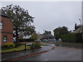
1
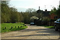
Private Road, Cricket Hill, Yateley
Nice road, nice houses, nice cars
Image: © Colin Haywood-Gray
Taken: 26 Apr 2006
0.16 miles
2
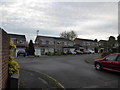
2016: a year on Geograph (Day 292)
Dungells Farm Close, Yateley
Image: © Basher Eyre
Taken: 18 Oct 2016
0.19 miles
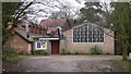
4
Yateley Baptist Church
Built in 1865 replacing the Zoar Chapel.
Image: © Michael FORD
Taken: Unknown
0.24 miles
5
2016: a year on Geograph (Day 314)
Looking from Lower Moor into Maple Gardens
Image: © Basher Eyre
Taken: 9 Nov 2016
0.24 miles
6
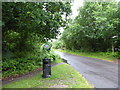
Dungells Lane, Yateley Common end
(taken at its junction with Tudor Drive)
Image: © Basher Eyre
Taken: 1 Jul 2016
0.24 miles
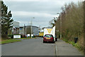
7
Aragon Road, Yateley
A side road off Aragon Road in the Blackbushe Business Park.
Image: © Alan Hunt
Taken: 18 Jul 2015
0.25 miles
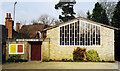
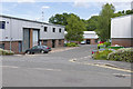
8
Access road, Blackbushe Business Centre
One of two ways in, the other has not got a mobile snack bar.
Image: © Robin Webster
Taken: 6 Mar 2014
0.25 miles