IMAGES TAKEN NEAR TO
Kingsley, BORDON, GU35 9NN
Introduction
This page details the photographs taken nearby to GU35 9NN by members of the Geograph project.
The Geograph project started in 2005 with the aim of publishing, organising and preserving representative images for every square kilometre of Great Britain, Ireland and the Isle of Man.

There are currently over 7.5m images from over14,400 individuals and you can help contribute to the project by visiting https://www.geograph.org.uk
Image Map (Loading...)


Getting Data...Please wait
Leaflet Map data © OpenStreetMap
Images are licensed for reuse under creativecommons.org/licenses/by-sa/2.0
Notes
- Clicking on the map will re-center to the selected point.
- The higher the marker number, the further away the image location is from the centre of the postcode.
Image Listing (8 Images Found)
Images are licensed for reuse under creativecommons.org/licenses/by-sa/2.0
Image
Details
Distance
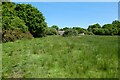
2
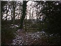
Kingsley Stream
This is one of the headwaters of the River Wey and here it flows through woodland. The sketchmap on a board by the bridge shows the way to the houses scattered in the woods.
Image: © Colin Smith
Taken: 17 Feb 2007
0.07 miles
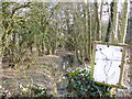
3
Rivulet by Woodland Farm
The footbridge crosses a shallow and wide stream, about 3-4 inches deep, which has a grass-covered bed.
Image: © Colin Smith
Taken: 17 Feb 2007
0.11 miles
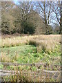
4
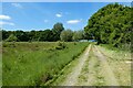
Woodland Farm, Binswood
The footpath past this farm crosses a mix of grassland and woodland in a flat Wealden area.
Image: © Colin Smith
Taken: 17 Feb 2007
0.17 miles
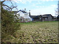
5
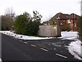
A house called "Foxes"
This is on the B3004 between east Worldham and Kingsley.
Image: © Shazz
Taken: 26 Dec 2010
0.17 miles
8
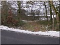
Bridleway near Green Street (B3004)
Once through the gate the bridleway turns left through the trees to run parallel with the road.
Image: © Shazz
Taken: 26 Dec 2010
0.23 miles