IMAGES TAKEN NEAR TO
Oakhanger Road, BORDON, GU35 9JA
Introduction
This page details the photographs taken nearby to Oakhanger Road, GU35 9JA by members of the Geograph project.
The Geograph project started in 2005 with the aim of publishing, organising and preserving representative images for every square kilometre of Great Britain, Ireland and the Isle of Man.

There are currently over 7.5m images from over14,400 individuals and you can help contribute to the project by visiting https://www.geograph.org.uk
Image Map (Loading...)


Getting Data...Please wait
Leaflet Map data © OpenStreetMap
Images are licensed for reuse under creativecommons.org/licenses/by-sa/2.0
Notes
- Clicking on the map will re-center to the selected point.
- The higher the marker number, the further away the image location is from the centre of the postcode.
Image Listing (8 Images Found)
Images are licensed for reuse under creativecommons.org/licenses/by-sa/2.0
Image
Details
Distance
1
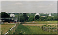
Oakhanger RAF Station
Detection installations.
Image: © Michael FORD
Taken: Unknown
0.06 miles
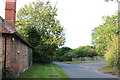
3
Road between Bordon and Oakhanger
The road on the left leads to a communications unit.
Image: © Shazz
Taken: 26 Dec 2010
0.12 miles
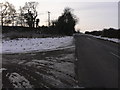
4
Oakhanger - southern approach
Up to the corner the road follows an old Roman route, which carried straight on to Silchester.
Image: © Robin Webster
Taken: 30 Jan 2016
0.13 miles
5
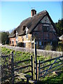
Thatched Cottage, Oakhanger
Another old half-timbered cottage, with brick infill. In front is a stile leading from the village street to the footpath.
Image: © Colin Smith
Taken: 3 Feb 2007
0.15 miles
6
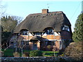
Hampshire Thatch, Oakhanger
A delightful brick infill, half-timbered thatched cottage on the village street.
Image: © Colin Smith
Taken: 3 Feb 2007
0.15 miles
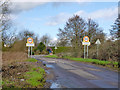
7
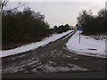
Road on The Warren near Oakhanger
This leads to a communications centre.
Image: © Shazz
Taken: 26 Dec 2010
0.20 miles
8
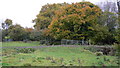
Field near Oakhanger
The bridge over Oakhanger Stream to the right is on a private farm track. The public footpath crosses the field to the gate on the left.
Image: © Shazz
Taken: 3 Nov 2008
0.24 miles