IMAGES TAKEN NEAR TO
Oakhanger, BORDON, GU35 9HT
Introduction
This page details the photographs taken nearby to GU35 9HT by members of the Geograph project.
The Geograph project started in 2005 with the aim of publishing, organising and preserving representative images for every square kilometre of Great Britain, Ireland and the Isle of Man.

There are currently over 7.5m images from over14,400 individuals and you can help contribute to the project by visiting https://www.geograph.org.uk
Image Map
Images are licensed for reuse under creativecommons.org/licenses/by-sa/2.0
Notes
- Clicking on the map will re-center to the selected point.
- The higher the marker number, the further away the image location is from the centre of the postcode.
Image Listing (4 Images Found)
Images are licensed for reuse under creativecommons.org/licenses/by-sa/2.0
Image
Details
Distance
1
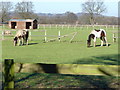
By Binbrook
"Horsieculture" on the pastures by Bordon. The land here is quite flat and mostly grassland.
Image: © Colin Smith
Taken: 3 Feb 2007
0.01 miles
2
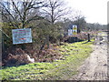
Military Training Area, The Warren, Bordon
This bridleway borders Bordon Camp training lands and the many signs warn the public to avoid all suspicious objects - they might go bang!
Image: © Colin Smith
Taken: 3 Feb 2007
0.08 miles
3
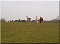
Alpacas near Bordon
On a footpath between Bordon and Oakhanger
Image: © easthantsxc
Taken: 1 Jan 2002
0.08 miles
4
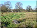
Footpath by Oakhanger Stream
Wooden plank bridges take walkers over the small ditches here which parallel the stream. The going is quite wet in this flat valley bottom.
Image: © Colin Smith
Taken: 3 Feb 2007
0.19 miles