IMAGES TAKEN NEAR TO
Furze Hill Road, BORDON, GU35 8HD
Introduction
This page details the photographs taken nearby to Furze Hill Road, GU35 8HD by members of the Geograph project.
The Geograph project started in 2005 with the aim of publishing, organising and preserving representative images for every square kilometre of Great Britain, Ireland and the Isle of Man.

There are currently over 7.5m images from over14,400 individuals and you can help contribute to the project by visiting https://www.geograph.org.uk
Image Map (Loading...)


Getting Data...Please wait
Leaflet Map data © OpenStreetMap
Images are licensed for reuse under creativecommons.org/licenses/by-sa/2.0
Notes
- Clicking on the map will re-center to the selected point.
- The higher the marker number, the further away the image location is from the centre of the postcode.
Image Listing (5 Images Found)
Images are licensed for reuse under creativecommons.org/licenses/by-sa/2.0
Image
Details
Distance
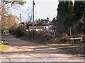
1
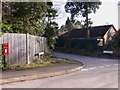
Road junction at Headley Down
Headley Down is a development east of Headley. Some of the roads are unmade. Here the camera is in Stonehill Road.
Image: © Shazz
Taken: 11 Feb 2010
0.11 miles
2
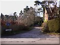
Another road junction at Headley Down
Headley Down is a development east of Headley. Some of the roads are unmade. Here the camera is in Stonehill Road.
Image: © Shazz
Taken: 11 Feb 2010
0.16 miles
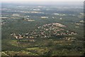
5
Yet another road junction at Headley Down
Headley Down is a development east of Headley. Some of the roads are unmade. Here the camera is in Stonehill Road.
Image: © Shazz
Taken: 11 Feb 2010
0.20 miles