IMAGES TAKEN NEAR TO
Windsor Walk, BORDON, GU35 0SE
Introduction
This page details the photographs taken nearby to Windsor Walk, GU35 0SE by members of the Geograph project.
The Geograph project started in 2005 with the aim of publishing, organising and preserving representative images for every square kilometre of Great Britain, Ireland and the Isle of Man.

There are currently over 7.5m images from over14,400 individuals and you can help contribute to the project by visiting https://www.geograph.org.uk
Image Map
Images are licensed for reuse under creativecommons.org/licenses/by-sa/2.0
Notes
- Clicking on the map will re-center to the selected point.
- The higher the marker number, the further away the image location is from the centre of the postcode.
Image Listing (68 Images Found)
Images are licensed for reuse under creativecommons.org/licenses/by-sa/2.0
Image
Details
Distance
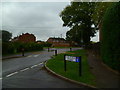
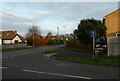
1

Looking from Chase Road into Washford Lane
Image: © Basher Eyre
Taken: 21 Dec 2021
0.04 miles
2
Chase Road between Five Acres Close and Taylors Lane
Image: © Shazz
Taken: 11 Oct 2013
0.04 miles
3

Looking from Chase Road into Taylors Lane
Image: © Basher Eyre
Taken: 21 Dec 2021
0.05 miles
4
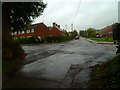
Crossroads in Lindford
The camera is in Canes Lane, Chase Road is the crossing road and Taylors Lane is ahead.
Image: © Shazz
Taken: 11 Oct 2013
0.05 miles
5
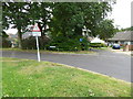
Shipwrights' Way 34
The Way goes left at this junction into Washford Lane.
Image: © Shazz
Taken: 21 Aug 2016
0.05 miles

7

Looking west on Canes Lane
The notice is admirable.
Image: © Shazz
Taken: 11 Oct 2013
0.07 miles
8

Looking from Chase Road into Five Acres Close
Image: © Basher Eyre
Taken: 21 Dec 2021
0.07 miles
9
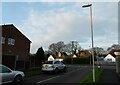
Approaching the junction of Pear Tree Road and Windsor Road
Image: © Basher Eyre
Taken: 21 Dec 2021
0.08 miles
10
Junction of Pear Tree Road and Windsor Road
Image: © Basher Eyre
Taken: 21 Dec 2021
0.08 miles