IMAGES TAKEN NEAR TO
Royal Drive, BORDON, GU35 0QF
Introduction
This page details the photographs taken nearby to Royal Drive, GU35 0QF by members of the Geograph project.
The Geograph project started in 2005 with the aim of publishing, organising and preserving representative images for every square kilometre of Great Britain, Ireland and the Isle of Man.

There are currently over 7.5m images from over14,400 individuals and you can help contribute to the project by visiting https://www.geograph.org.uk
Image Map
Images are licensed for reuse under creativecommons.org/licenses/by-sa/2.0
Notes
- Clicking on the map will re-center to the selected point.
- The higher the marker number, the further away the image location is from the centre of the postcode.
Image Listing (17 Images Found)
Images are licensed for reuse under creativecommons.org/licenses/by-sa/2.0
Image
Details
Distance
1
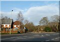
Looking from St Lucia Park across Lindford Road towards Royal Drive
Image: © Basher Eyre
Taken: 21 Dec 2021
0.07 miles
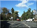
3
Traffic lights on Camp Road, Bordon
The RAF fire station is behind the trees on the right opposite.
Image: © David Howard
Taken: 14 Oct 2012
0.09 miles
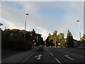
4
Bordon : queue at the lights
a common sight in this army town.
Image: © Ray Stanton
Taken: 6 Sep 2006
0.09 miles
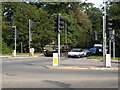
5
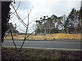
Construction of A325/B3002 Roundabout
Construction of new bypass (A325/ Louisburg Avenue) in March 2016, as seen from neighbouring woods. The photo shows the area after it was cleared of trees and when the first ground works were going on. A new roundabout was built where the old road can be seen in the photograph.
Image: © BHelas
Taken: 15 Mar 2016
0.11 miles
6
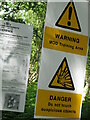
Warning signs Broxhead Common
MoD signs on footpath onto Broxhead Common. Sign on left informs readers Aldershot Military District byelaws apply. The public is permitted within this area.
Broxhead Common is a nationally important site, designated as an SSSI and Local Nature Reserve. It is part of the Wealdean Heaths Phase 2 Special Protection Area for the Conservation of Wild Birds.
Image: © BHelas
Taken: 17 Jun 2014
0.11 miles
8
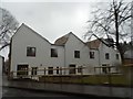
Whitehill-Bordon Eco-town terrace
By pure chance the day I took these (in the pouring rain as it turned out) it was the open day for the competition winning designs chosen for the small area of grassland next to the now closed fire station. http://ashsak.com/eco-town-terrace/
Image: © David Howard
Taken: 1 Mar 2015
0.13 miles
10
RAF Fire Station, Bordon
Recently closed. Bordon fire station (part of Hampshire Fire & Rescue Service) is in a different location.
Image: © Ray Stanton
Taken: 6 Sep 2006
0.15 miles