IMAGES TAKEN NEAR TO
Lindford Road, BORDON, GU35 0LL
Introduction
This page details the photographs taken nearby to Lindford Road, GU35 0LL by members of the Geograph project.
The Geograph project started in 2005 with the aim of publishing, organising and preserving representative images for every square kilometre of Great Britain, Ireland and the Isle of Man.

There are currently over 7.5m images from over14,400 individuals and you can help contribute to the project by visiting https://www.geograph.org.uk
Image Map (Loading...)


Getting Data...Please wait
Leaflet Map data © OpenStreetMap
Images are licensed for reuse under creativecommons.org/licenses/by-sa/2.0
Notes
- Clicking on the map will re-center to the selected point.
- The higher the marker number, the further away the image location is from the centre of the postcode.
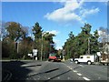
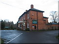
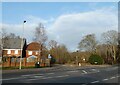
Image Listing (20 Images Found)
Images are licensed for reuse under creativecommons.org/licenses/by-sa/2.0
Image
Details
Distance
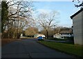
2
Looking from St Lucia Park across Lindford Road towards Royal Drive
Image: © Basher Eyre
Taken: 21 Dec 2021
0.10 miles
3
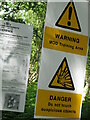
Warning signs Broxhead Common
MoD signs on footpath onto Broxhead Common. Sign on left informs readers Aldershot Military District byelaws apply. The public is permitted within this area.
Broxhead Common is a nationally important site, designated as an SSSI and Local Nature Reserve. It is part of the Wealdean Heaths Phase 2 Special Protection Area for the Conservation of Wild Birds.
Image: © BHelas
Taken: 17 Jun 2014
0.13 miles
4

The Lindford Oak
This tree is called the Lindford Oak despite the fact it is not within Lindford Parish but in the parish of Whitehill. The boundary is along the River Wey.
Image: © Shazz
Taken: 11 Oct 2013
0.13 miles
5
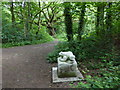
The Lindford Oak seen with toad sculpture
The oak is also seen at Image
Image: © Shazz
Taken: 28 May 2015
0.16 miles
6
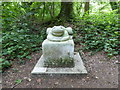
Natterjack toad on the Shipwrights' Way
This sculpture was not here when I last visited the Shipwrights' Way in October 2013 (see http://www.geograph.org.uk/geotrips/678 ). The walk had been "opened" on 24th March of that year. As I submit this image there is STILL a gap where the walk is not complete between Lindford and Liphook. I wonder when it will EVER be complete. Why open a route over two years before completion?
Information about the sculpture is at Image
Note added 23rd August 2016: When I wrote the above I believed the main route was to go through Liphook but that turned out to be a spur to the main route which in fact goes through Liss. The Bordon to Liss section opened a few days ago.
Image: © Shazz
Taken: 28 May 2015
0.16 miles
7
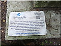
Information about sculpture in the woods at Lindford
The sculpture itself is seen at Image
Image: © Shazz
Taken: 28 May 2015
0.16 miles
8
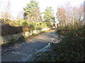
Path on Broxhead Common
The road and wall look as if they had a military origin.
Image: © David960
Taken: 29 Dec 2013
0.17 miles