IMAGES TAKEN NEAR TO
Compton Place, BORDON, GU35 0GZ
Introduction
This page details the photographs taken nearby to Compton Place, GU35 0GZ by members of the Geograph project.
The Geograph project started in 2005 with the aim of publishing, organising and preserving representative images for every square kilometre of Great Britain, Ireland and the Isle of Man.

There are currently over 7.5m images from over14,400 individuals and you can help contribute to the project by visiting https://www.geograph.org.uk
Image Map
Images are licensed for reuse under creativecommons.org/licenses/by-sa/2.0
Notes
- Clicking on the map will re-center to the selected point.
- The higher the marker number, the further away the image location is from the centre of the postcode.
Image Listing (8 Images Found)
Images are licensed for reuse under creativecommons.org/licenses/by-sa/2.0
Image
Details
Distance
1
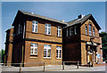
St George, Bordon
Built as the RA Institute but converted to the Garrison Church in 1983.
Image: © Michael FORD
Taken: Unknown
0.11 miles
3

2016: a year on Geograph (Day 131)
Looking from Ennerdale Road into Ullswater Close
Image: © Basher Eyre
Taken: 10 May 2016
0.14 miles
4
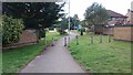
Footpath joining two roads
This footpath cuts through from Loweswater Garden Road to Ennerdale Road on a residential estate in Bordon.
Image: © John P Reeves
Taken: 25 Sep 2018
0.21 miles
5
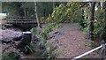
Footbridge over stream at Bordon Camp
This was taken from station road and a large playing field can be glimpsed on the left.
Image: © Shazz
Taken: 9 Oct 2009
0.24 miles
6

2016: a year on Geograph (Day 78)
Pinewood Village Hall, Rydal Close
Image: © Basher Eyre
Taken: 18 Mar 2016
0.24 miles
7

Bordon & Whitehill War Memorial: mid March 2016
Image: © Basher Eyre
Taken: 18 Mar 2016
0.24 miles
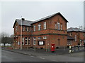
8
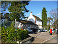
Bordon post office
This still appears to be used by the Royal Mail, but apparently has no public counter.
Image: © Robin Webster
Taken: 11 Feb 2016
0.24 miles