
IMAGES TAKEN NEAR TO
Signal Hill Road, BORDON, GU35 0GN
Introduction
This page details the photographs taken nearby to Signal Hill Road, GU35 0GN by members of the Geograph project.
The Geograph project started in 2005 with the aim of publishing, organising and preserving representative images for every square kilometre of Great Britain, Ireland and the Isle of Man.

There are currently over 7.5m images from over14,400 individuals and you can help contribute to the project by visiting https://www.geograph.org.uk
Image Map
Images are licensed for reuse under creativecommons.org/licenses/by-sa/2.0
Notes
- Clicking on the map will re-center to the selected point.
- The higher the marker number, the further away the image location is from the centre of the postcode.
Image Listing (4 Images Found)
Images are licensed for reuse under creativecommons.org/licenses/by-sa/2.0
Image
Details
Distance
1
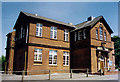
St George, Bordon
Built as the RA Institute but converted to the Garrison Church in 1983.
Image: © Michael FORD
Taken: Unknown
0.09 miles
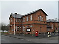
3
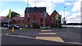
Sales & Information Centre
This building, on the corner end of Barbados Road next to the new roundabout is the Barratt Homes Sales & Information Centre for the new residential area that has been built in this area.
Image: © John P Reeves
Taken: 25 Sep 2018
0.17 miles
4
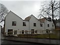
Whitehill-Bordon Eco-town terrace
By pure chance the day I took these (in the pouring rain as it turned out) it was the open day for the competition winning designs chosen for the small area of grassland next to the now closed fire station. http://ashsak.com/eco-town-terrace/
Image: © David Howard
Taken: 1 Mar 2015
0.24 miles