IMAGES TAKEN NEAR TO
Pinehill Road, BORDON, GU35 0AZ
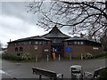
Introduction
This page details the photographs taken nearby to Pinehill Road, GU35 0AZ by members of the Geograph project.
The Geograph project started in 2005 with the aim of publishing, organising and preserving representative images for every square kilometre of Great Britain, Ireland and the Isle of Man.

There are currently over 7.5m images from over14,400 individuals and you can help contribute to the project by visiting https://www.geograph.org.uk
Image Map
Images are licensed for reuse under creativecommons.org/licenses/by-sa/2.0
Notes
- Clicking on the map will re-center to the selected point.
- The higher the marker number, the further away the image location is from the centre of the postcode.
Image Listing (103 Images Found)
Images are licensed for reuse under creativecommons.org/licenses/by-sa/2.0
Image
Details
Distance
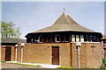
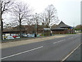
1
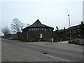
A lunchtime stroll around Bordon (79)
St Mark's Church
Image: © Basher Eyre
Taken: 16 Nov 2011
0.00 miles
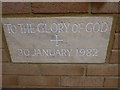
2
St Mark, Bordon
Modern brick built Ecumenical Church.
Image: © Michael FORD
Taken: Unknown
0.01 miles
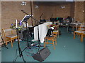
3
A lunchtime stroll around Bordon (82)
Looking back to St Mark's Church.
Image: © Basher Eyre
Taken: 16 Nov 2011
0.01 miles
6
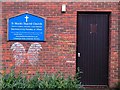
St Mark's Shared Church Door, Bordon, Hampshire - 190918
Detail of the side door and some interesting chalked angel wings and graffiti.
Image: © John P Reeves
Taken: 19 Sep 2018
0.01 miles
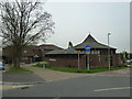
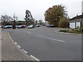
7
A lunchtime stroll around Bordon (78)
Looking towards the parish church in Pinehill Road.
Image: © Basher Eyre
Taken: 16 Nov 2011
0.02 miles
8
A lunchtime stroll around Bordon (85)
Looking towards The Co-Op car park
Image: © Basher Eyre
Taken: 16 Nov 2011
0.02 miles