IMAGES TAKEN NEAR TO
Doe Mews, ALTON, GU34 5TG
Introduction
This page details the photographs taken nearby to Doe Mews, GU34 5TG by members of the Geograph project.
The Geograph project started in 2005 with the aim of publishing, organising and preserving representative images for every square kilometre of Great Britain, Ireland and the Isle of Man.

There are currently over 7.5m images from over14,400 individuals and you can help contribute to the project by visiting https://www.geograph.org.uk
Image Map
Images are licensed for reuse under creativecommons.org/licenses/by-sa/2.0
Notes
- Clicking on the map will re-center to the selected point.
- The higher the marker number, the further away the image location is from the centre of the postcode.
Image Listing (30 Images Found)
Images are licensed for reuse under creativecommons.org/licenses/by-sa/2.0
Image
Details
Distance
1
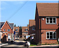
Thornybush Gardens, Four Marks
A new development on the eastern side of Boyneswood Road.
Image: © Andrew Smith
Taken: 27 Sep 2009
0.14 miles
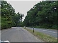
2
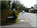
Looking south on Boyneswood Road from Friars Oak
Image: © Shazz
Taken: 24 Mar 2014
0.15 miles
5
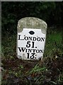
Old Milestone by the A31, Winchester Road, Four Marks
Metal plate attached to stone post by the A31, in parish of FOUR MARKS (EAST HAMPSHIRE District), Winchester Road, Four Marks, between road and footpath, on North side of road. Tasker block, erected by the Winchester & Alton, Lower District turnpike trust in the 19th century.
Inscription reads:-
LONDON
51.
WINTON
13.
Maker:-
TASKER
Milestone Society National ID: HA_WIAL13.
Image: © K Lawrence
Taken: 31 Dec 2002
0.17 miles
6
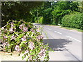
Boyneswood Road
Upmarket residential road in the southern area of the scattered village of Medstead.
Image: © Colin Smith
Taken: 21 May 2011
0.17 miles
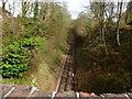
7
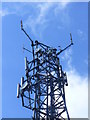
Top of the Tower
Telecommunications tower rising above the canopy of Chawton Park Wood.
Image: © Colin Smith
Taken: 21 May 2011
0.18 miles
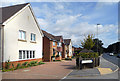
8
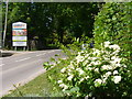
Boyneswood Road, Medstead
Residential road with signs of further housing development.
Image: © Colin Smith
Taken: 21 May 2011
0.19 miles
10
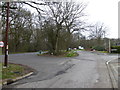
Junction of The Shrave and Woodlark Place
The traffic is on the A31.
Image: © Shazz
Taken: 24 Mar 2014
0.19 miles