IMAGES TAKEN NEAR TO
Jenny Green Lane, ALTON, GU34 5NU
Introduction
This page details the photographs taken nearby to Jenny Green Lane, GU34 5NU by members of the Geograph project.
The Geograph project started in 2005 with the aim of publishing, organising and preserving representative images for every square kilometre of Great Britain, Ireland and the Isle of Man.

There are currently over 7.5m images from over14,400 individuals and you can help contribute to the project by visiting https://www.geograph.org.uk
Image Map (Loading...)


Getting Data...Please wait
Leaflet Map data © OpenStreetMap
Images are licensed for reuse under creativecommons.org/licenses/by-sa/2.0
Notes
- Clicking on the map will re-center to the selected point.
- The higher the marker number, the further away the image location is from the centre of the postcode.
Image Listing (8 Images Found)
Images are licensed for reuse under creativecommons.org/licenses/by-sa/2.0
Image
Details
Distance
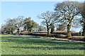
1
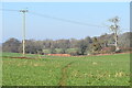
Farmland, house and woodland, Bentworth
On the south side of Jennie Green Lane, a byway between Bentworth and Medstead.
Image: © Andrew Smith
Taken: 27 Sep 2009
0.04 miles
2
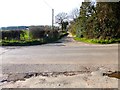
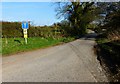
Jennie Green Lane crosses Trinity Road
Here Jennie Green Lane changes from a road to a byway.
Image: © Shazz
Taken: 29 Mar 2014
0.13 miles
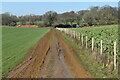
4
Jennie Green Lane after the rain
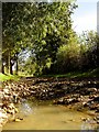
Puddles form among the flints on a downland green lane.
Image: © Hugh Chevallier
Taken: 20 Oct 2006
0.16 miles
5
Jennie Green Lane looking east from Trinity Road
Image: © Shazz
Taken: 29 Mar 2014
0.19 miles
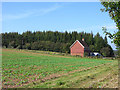
7
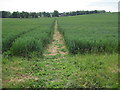
Path across field north from Trinity Farm
Image: © David Martin
Taken: 21 Jan 2023
0.22 miles