IMAGES TAKEN NEAR TO
Homestead Road, ALTON, GU34 5NA
Introduction
This page details the photographs taken nearby to Homestead Road, GU34 5NA by members of the Geograph project.
The Geograph project started in 2005 with the aim of publishing, organising and preserving representative images for every square kilometre of Great Britain, Ireland and the Isle of Man.

There are currently over 7.5m images from over14,400 individuals and you can help contribute to the project by visiting https://www.geograph.org.uk
Image Map (Loading...)


Getting Data...Please wait
Leaflet Map data © OpenStreetMap
Images are licensed for reuse under creativecommons.org/licenses/by-sa/2.0
Notes
- Clicking on the map will re-center to the selected point.
- The higher the marker number, the further away the image location is from the centre of the postcode.
Image Listing (8 Images Found)
Images are licensed for reuse under creativecommons.org/licenses/by-sa/2.0
Image
Details
Distance
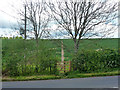
1
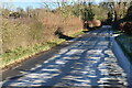
Frost and fence shadows on Bighton Road
Image: © David Martin
Taken: 21 Jan 2023
0.14 miles
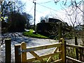
4
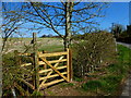
Start of footpath to Hattingley
At the junction of Goatacre Road with Bighton Road.
Image: © Robin Webster
Taken: 13 May 2014
0.17 miles
5
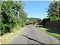
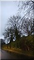
Bighton Road junction with Goatacre Road
Image: © Stuart Logan
Taken: 7 Sep 2012
0.17 miles
6
Junction of Bighton and Goatacre roads seen from footpath
Image: © Shazz
Taken: 29 Mar 2014
0.17 miles
7
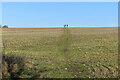
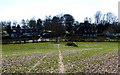
Walkers on the horizon
On the footpath to Hattingley.
Image: © David Martin
Taken: 21 Jan 2023
0.19 miles