IMAGES TAKEN NEAR TO
Roe Downs Road, ALTON, GU34 5LG
Introduction
This page details the photographs taken nearby to Roe Downs Road, GU34 5LG by members of the Geograph project.
The Geograph project started in 2005 with the aim of publishing, organising and preserving representative images for every square kilometre of Great Britain, Ireland and the Isle of Man.

There are currently over 7.5m images from over14,400 individuals and you can help contribute to the project by visiting https://www.geograph.org.uk
Image Map
Images are licensed for reuse under creativecommons.org/licenses/by-sa/2.0
Notes
- Clicking on the map will re-center to the selected point.
- The higher the marker number, the further away the image location is from the centre of the postcode.
Image Listing (10 Images Found)
Images are licensed for reuse under creativecommons.org/licenses/by-sa/2.0
Image
Details
Distance
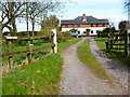
3
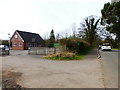
Medstead Lawn Tennis Club
This is right next to the Bowls Club. See Image
Image: © Shazz
Taken: 24 Mar 2014
0.11 miles
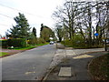
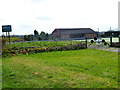
5

Medstead Village Hall and start of footpath going east
Another view of the Hall is at http://www.geograph.org.uk/photo/3480394.
Image: © Shazz
Taken: 24 Mar 2014
0.17 miles
6
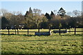
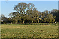
Water troughs in fields near Medstead Green
Image: © David Martin
Taken: 21 Jan 2023
0.18 miles
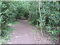
8

Medstead Village Hall and a bench on the green
Image: © David Martin
Taken: 27 May 2013
0.20 miles