IMAGES TAKEN NEAR TO
Holly Drive, ALTON, GU34 5GH
Introduction
This page details the photographs taken nearby to Holly Drive, GU34 5GH by members of the Geograph project.
The Geograph project started in 2005 with the aim of publishing, organising and preserving representative images for every square kilometre of Great Britain, Ireland and the Isle of Man.

There are currently over 7.5m images from over14,400 individuals and you can help contribute to the project by visiting https://www.geograph.org.uk
Image Map
Images are licensed for reuse under creativecommons.org/licenses/by-sa/2.0
Notes
- Clicking on the map will re-center to the selected point.
- The higher the marker number, the further away the image location is from the centre of the postcode.
Image Listing (25 Images Found)
Images are licensed for reuse under creativecommons.org/licenses/by-sa/2.0
Image
Details
Distance
1
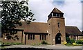
The Good Shepherd, Four Marks
Built in 1956.
Image: © Michael FORD
Taken: Unknown
0.08 miles
2
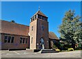
Church of the Good Shepherd: mid February 2023
Image: © Basher Eyre
Taken: 14 Feb 2023
0.10 miles
3
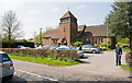
Parish Church of the Good Shepherd, Lyminton Bottom
See http://www.goodshepherd.hampshire.org.uk/ .
Image: © Peter Facey
Taken: 19 Apr 2009
0.11 miles
4
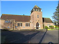
The Good Shepherd Church at Four Marks
Looking north-westward.
Image: © Peter Wood
Taken: 28 Feb 2017
0.11 miles
5
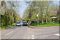
Crossroads on Lymington Bottom
The road at right is Blackberry Lane.
Image: © Peter Facey
Taken: 19 Apr 2009
0.11 miles
6
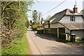
Keepsake Cottage
Keepsake Cottage is the red tiled property.
Image: © Peter Facey
Taken: 19 Apr 2009
0.13 miles
7
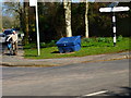
Signpost at crossroads on Lymington Bottom
Brislands Lane is left and Blackberry Lane is to the right.
Image: © Shazz
Taken: 9 Mar 2014
0.13 miles
8
Blackberry Lane crosses Lymington Bottom
Image: © Peter Facey
Taken: 19 Apr 2009
0.14 miles
9
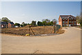
Meadow Brook housing development site
Barratt Homes was developing this site at time of photographing. This area is SSE of the already-built Lapwing Way.
(coordinates estimated due to lack of OS mapping)
Image: © Peter Facey
Taken: 19 Apr 2009
0.14 miles
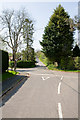
10
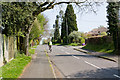
Blackberry Lane
From its crossroads with Lymington Bottom.
Image: © Peter Facey
Taken: 19 Apr 2009
0.15 miles