IMAGES TAKEN NEAR TO
Blacknest Road, ALTON, GU34 4QL
Introduction
This page details the photographs taken nearby to Blacknest Road, GU34 4QL by members of the Geograph project.
The Geograph project started in 2005 with the aim of publishing, organising and preserving representative images for every square kilometre of Great Britain, Ireland and the Isle of Man.

There are currently over 7.5m images from over14,400 individuals and you can help contribute to the project by visiting https://www.geograph.org.uk
Image Map (Loading...)


Getting Data...Please wait
Leaflet Map data © OpenStreetMap
Images are licensed for reuse under creativecommons.org/licenses/by-sa/2.0
Notes
- Clicking on the map will re-center to the selected point.
- The higher the marker number, the further away the image location is from the centre of the postcode.
Image Listing (6 Images Found)
Images are licensed for reuse under creativecommons.org/licenses/by-sa/2.0
Image
Details
Distance
1
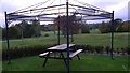
Blacknest Golf Club
This table is behind the clubhouse and has a view of some of the course.
Image: © Shazz
Taken: 21 Oct 2009
0.03 miles
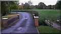
2
Golf buggies lined up at Blacknest Golf Course
Hiring a buggy costs £15 per round. The clubhouse is on the right.
Image: © Shazz
Taken: 21 Oct 2009
0.03 miles
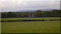
4
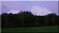
Blacknest Golf Club
This part of the course is near to the entrance from Frith End Road. The clouds are better looking.
Image: © Shazz
Taken: 21 Oct 2009
0.13 miles
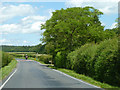
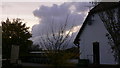
6
Fields near Bucks Horn Oak
The buildings are on Frith End Road.
Image: © Shazz
Taken: 21 Oct 2009
0.24 miles