IMAGES TAKEN NEAR TO
River Hill, ALTON, GU34 4QH
Introduction
This page details the photographs taken nearby to River Hill, GU34 4QH by members of the Geograph project.
The Geograph project started in 2005 with the aim of publishing, organising and preserving representative images for every square kilometre of Great Britain, Ireland and the Isle of Man.

There are currently over 7.5m images from over14,400 individuals and you can help contribute to the project by visiting https://www.geograph.org.uk
Image Map
Images are licensed for reuse under creativecommons.org/licenses/by-sa/2.0
Notes
- Clicking on the map will re-center to the selected point.
- The higher the marker number, the further away the image location is from the centre of the postcode.
Image Listing (10 Images Found)
Images are licensed for reuse under creativecommons.org/licenses/by-sa/2.0
Image
Details
Distance
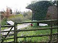
1
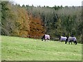
Paddock at River Hill Farm
The farm specialises in horses and stables. Here is one of the paddocks, looking towards Boxall's Copse, and yes the photo is level.
Image: © Graham Horn
Taken: 25 Nov 2007
0.11 miles
2
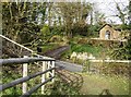
Entrance to River Hill Farm
The lane past the farm rises steeply from right to left. This footpath goes son to join it then goes up the bank near the greenest of the trees. The first of the buildings of River Hill Farm are to the right.
Image: © Graham Horn
Taken: 25 Nov 2007
0.12 miles
3
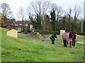
Are you going for a walk?
As I came along the footpath from the gate these horses came along and started following me, obviously wanting to be taken for a walk. This is one of the paddocks of River Hill Farm (background, next square) which seems to have many horses.
Image: © Graham Horn
Taken: 25 Nov 2007
0.13 miles
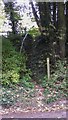
6
Footpath to Burnfort?
The sign is pointing roughly the right way, but the location is miles wrong, not even on the same island. Fortunately the footpath is clear, to the left of the stable block.
Image: © Graham Horn
Taken: 25 Nov 2007
0.15 miles
7
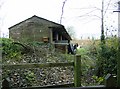
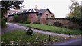
Mucking out the stables
A row of five stables adjacent to the footpath. Evidence of mucking out, saddlecloths on the rail for example, but all was quiet as I passed.
Image: © Graham Horn
Taken: 25 Nov 2007
0.15 miles
8
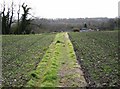
Footpath to River Hill Farm
Originally this path may have formed a field boundary. Although it goes straight across a field it is clearly delineated, with separate farming operations either side (same crop). Would that all cross-field paths were as clear.
Image: © Graham Horn
Taken: 25 Nov 2007
0.19 miles
9
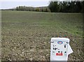
10" pipeline
At various locations in this area one finds these signs, referring to an oil pipeline under ground here. I can work out that it is a 10" pipe, the flow is away from us and it is probably 4.3 km from somewhere.
Image: © Graham Horn
Taken: 25 Nov 2007
0.21 miles
10
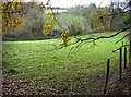
Pasture of Camices Farm
The footpath skirts round a small hollow which consists of a bit of straggly woodland and this grazing field.
Image: © Graham Horn
Taken: 25 Nov 2007
0.22 miles