IMAGES TAKEN NEAR TO
River Hill, ALTON, GU34 4PQ
Introduction
This page details the photographs taken nearby to River Hill, GU34 4PQ by members of the Geograph project.
The Geograph project started in 2005 with the aim of publishing, organising and preserving representative images for every square kilometre of Great Britain, Ireland and the Isle of Man.

There are currently over 7.5m images from over14,400 individuals and you can help contribute to the project by visiting https://www.geograph.org.uk
Image Map
Images are licensed for reuse under creativecommons.org/licenses/by-sa/2.0
Notes
- Clicking on the map will re-center to the selected point.
- The higher the marker number, the further away the image location is from the centre of the postcode.
Image Listing (18 Images Found)
Images are licensed for reuse under creativecommons.org/licenses/by-sa/2.0
Image
Details
Distance
1
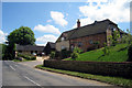
Oast House at Carnices Farmhouse, The Street, Binsted, Hampshire
Image: © Oast House Archive
Taken: 24 Jun 2009
0.01 miles
2
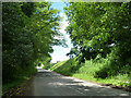
Road near Binstead Place
Heading towards the centre of the small village of Binstead.
Image: © Robin Webster
Taken: 8 Jun 2014
0.15 miles
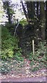
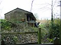
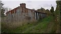
3
Footpath towards Camices Farm
The barn is part of Camices Farm, in the next square. However, the footpath stays in this square, turning right just beyond the pheasant feeding bin.
Image: © Graham Horn
Taken: 25 Nov 2007
0.15 miles
5
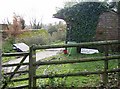
Footpath to Burnfort?
The sign is pointing roughly the right way, but the location is miles wrong, not even on the same island. Fortunately the footpath is clear, to the left of the stable block.
Image: © Graham Horn
Taken: 25 Nov 2007
0.15 miles
6
Mucking out the stables
A row of five stables adjacent to the footpath. Evidence of mucking out, saddlecloths on the rail for example, but all was quiet as I passed.
Image: © Graham Horn
Taken: 25 Nov 2007
0.16 miles
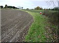
7
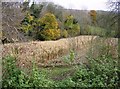
Pheasant territory
This hollow consists of straggly woodland and a half cut small field of maize. With feeding bins nearby, this is probably managed for pheasant rearing.
Image: © Graham Horn
Taken: 25 Nov 2007
0.16 miles
8
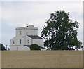
Telegraph House, Binsted
Now a private house, this was built by the Admiralty in 1825 as a semaphore relay station linking London with Plymouth. (There was already a successful chain of similar stations connecting London with Portsmouth.) The views from Telegraph House (149m) stretch, quite literally, in every direction for several miles.
Image: © Hugh Chevallier
Taken: 12 Sep 2006
0.16 miles
10
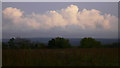
Field by Wheatley Lane
The clouds are the stars of this picture.
Image: © Shazz
Taken: 21 Oct 2009
0.16 miles