IMAGES TAKEN NEAR TO
Wheatley Lane, ALTON, GU34 4PG
Introduction
This page details the photographs taken nearby to Wheatley Lane, GU34 4PG by members of the Geograph project.
The Geograph project started in 2005 with the aim of publishing, organising and preserving representative images for every square kilometre of Great Britain, Ireland and the Isle of Man.

There are currently over 7.5m images from over14,400 individuals and you can help contribute to the project by visiting https://www.geograph.org.uk
Image Map
Images are licensed for reuse under creativecommons.org/licenses/by-sa/2.0
Notes
- Clicking on the map will re-center to the selected point.
- The higher the marker number, the further away the image location is from the centre of the postcode.
Image Listing (12 Images Found)
Images are licensed for reuse under creativecommons.org/licenses/by-sa/2.0
Image
Details
Distance
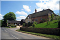
2
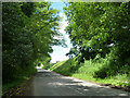
Road near Binstead Place
Heading towards the centre of the small village of Binstead.
Image: © Robin Webster
Taken: 8 Jun 2014
0.09 miles
3
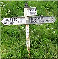
Direction Sign - Signpost on London Road, Binsted
Missing finial - 3 arms; by the UC road, in parish of Binsted (East Hampshire District), on the north side of the T junction of London Road and Wheatley Lane.
surveyed
Milestone Society National ID: HA_SU7841
Image: © A Savill
Taken: Unknown
0.11 miles
4
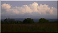
Field by Wheatley Lane
The clouds are the stars of this picture.
Image: © Shazz
Taken: 21 Oct 2009
0.12 miles
5
Footpath towards Camices Farm
The barn is part of Camices Farm, in the next square. However, the footpath stays in this square, turning right just beyond the pheasant feeding bin.
Image: © Graham Horn
Taken: 25 Nov 2007
0.16 miles
6
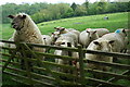
Sheep!
Round copse is in the distance. The sheep that is upright was bleating at me for the whole time I was there. They were obviously due to be fed, as I left the farmer pulled up.
Image: © Andrya Prescott
Taken: 14 May 2006
0.16 miles
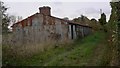
8
Oast House at Carnices Farmhouse, The Street, Binsted, Hampshire
Image: © Oast House Archive
Taken: 24 Jun 2009
0.19 miles
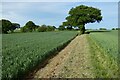
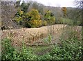
9
Footpath above Wheatley Lane
The start of the footpath above Wheatley Lane is not promising but it gets better. It follows the boundary between two fields, one in full kale production the other recently ploughed, but possibly not yet cropped.
Image: © Graham Horn
Taken: 25 Nov 2007
0.22 miles
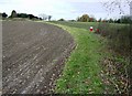
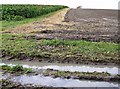
10
Pheasant territory
This hollow consists of straggly woodland and a half cut small field of maize. With feeding bins nearby, this is probably managed for pheasant rearing.
Image: © Graham Horn
Taken: 25 Nov 2007
0.23 miles