IMAGES TAKEN NEAR TO
Hay Place Lane, ALTON, GU34 4PE
Introduction
This page details the photographs taken nearby to Hay Place Lane, GU34 4PE by members of the Geograph project.
The Geograph project started in 2005 with the aim of publishing, organising and preserving representative images for every square kilometre of Great Britain, Ireland and the Isle of Man.

There are currently over 7.5m images from over14,400 individuals and you can help contribute to the project by visiting https://www.geograph.org.uk
Image Map (Loading...)


Getting Data...Please wait
Leaflet Map data © OpenStreetMap
Images are licensed for reuse under creativecommons.org/licenses/by-sa/2.0
Notes
- Clicking on the map will re-center to the selected point.
- The higher the marker number, the further away the image location is from the centre of the postcode.
Image Listing (16 Images Found)
Images are licensed for reuse under creativecommons.org/licenses/by-sa/2.0
Image
Details
Distance
1
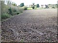
Farmland east of Hay Place
The houses on the horizon are part of a series of buildings making up Hay Place. A good footpath runs to the east around this recently ploughed field.
Image: © Graham Horn
Taken: 25 Nov 2007
0.04 miles
2
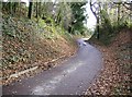
Route to Hay Place
This lane is designated as a footpath, but it also carries vehicular traffic as it is the route to Hay Place. The first house of the hamlet are just around the corner.
Image: © Graham Horn
Taken: 25 Nov 2007
0.04 miles
3
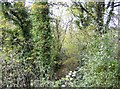
Copse near Hay Place
This small copse lines the valley of a small stream and is crossed here by a good footpath.
Image: © Graham Horn
Taken: 25 Nov 2007
0.11 miles
5
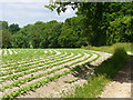
Potato Crop near Hay Place
Early summer shoots showing on the ridges of this Downland field south-east of Binsted.
http://www.bentleyvillage.com/homepage.htm
Image: © Colin Smith
Taken: 12 Jun 2010
0.15 miles
6
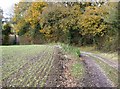
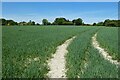
Footpath towards Binsted
This well-made footpath in the eastern part of the square is popular with dog walkers. It is flanked by arable fields, the one on the left developing a promising crop.
Image: © Graham Horn
Taken: 25 Nov 2007
0.15 miles
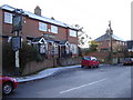
7
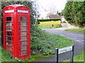
Services in Binsted
The telephone box is marked on the map, but it does not indicate that this is one of the dying breed of red boxes. Post boxes are more plentiful, but probably ought to be marked on the map these days.
Image: © Graham Horn
Taken: 25 Nov 2007
0.16 miles
9
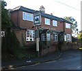
The Cedars, Binsted
Another village with no shops but at least the pub is still open.
Image: © Graham Clutton
Taken: 28 Dec 2005
0.20 miles
10

The Cedars Pub CL Campsite, Binstead
This is the Cedars Pub campsite in Binstead.
You can ONLY stay here if you are a member of the Caravan Club.
Only 5 members can stay at one time; its open all year round weather permitting.
Plenty of walking and places of interest to explore.
Image: © dinglefoot
Taken: 15 Aug 2009
0.20 miles