IMAGES TAKEN NEAR TO
Lower Froyle, ALTON, GU34 4LW
Introduction
This page details the photographs taken nearby to GU34 4LW by members of the Geograph project.
The Geograph project started in 2005 with the aim of publishing, organising and preserving representative images for every square kilometre of Great Britain, Ireland and the Isle of Man.

There are currently over 7.5m images from over14,400 individuals and you can help contribute to the project by visiting https://www.geograph.org.uk
Image Map (Loading...)


Getting Data...Please wait
Leaflet Map data © OpenStreetMap
Images are licensed for reuse under creativecommons.org/licenses/by-sa/2.0
Notes
- Clicking on the map will re-center to the selected point.
- The higher the marker number, the further away the image location is from the centre of the postcode.
Image Listing (15 Images Found)
Images are licensed for reuse under creativecommons.org/licenses/by-sa/2.0
Image
Details
Distance
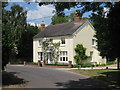
1
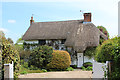
Long Barlands
Grade II listed http://list.english-heritage.org.uk/resultsingle.aspx?uid=1302223 thatched cottage.
Image: © Oast House Archive
Taken: 19 May 2013
0.02 miles
2
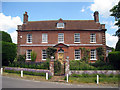
Rock House Farm, Froyle, Hampshire
Image: © Oast House Archive
Taken: 24 Jun 2009
0.04 miles
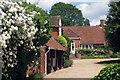
5
House at Little Rock, Lower Froyle
Image: © Oast House Archive
Taken: 24 Jun 2009
0.07 miles
6
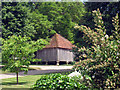
Granary at Rock House Farm
Grade II listed.
Image: © Oast House Archive
Taken: 24 Jun 2009
0.07 miles
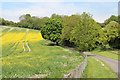
7
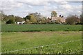
Lower Froyle
Approaching the village from the west on the minor road around mid-square.
Image: © Brendan and Ruth McCartney
Taken: 18 Apr 2005
0.13 miles
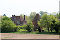
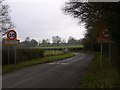
9
Oast at Hodges Farmhouse, Lower Froyle, Hampshire
Image: © Oast House Archive
Taken: 24 Jun 2009
0.16 miles
10
Hodges, Froyle, Hampshire
Grade II* listed.
Image: © Oast House Archive
Taken: 24 Jun 2009
0.17 miles