IMAGES TAKEN NEAR TO
Lower Froyle, ALTON, GU34 4LJ
Introduction
This page details the photographs taken nearby to GU34 4LJ by members of the Geograph project.
The Geograph project started in 2005 with the aim of publishing, organising and preserving representative images for every square kilometre of Great Britain, Ireland and the Isle of Man.

There are currently over 7.5m images from over14,400 individuals and you can help contribute to the project by visiting https://www.geograph.org.uk
Image Map
Images are licensed for reuse under creativecommons.org/licenses/by-sa/2.0
Notes
- Clicking on the map will re-center to the selected point.
- The higher the marker number, the further away the image location is from the centre of the postcode.
Image Listing (18 Images Found)
Images are licensed for reuse under creativecommons.org/licenses/by-sa/2.0
Image
Details
Distance
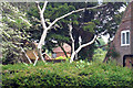
3
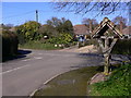
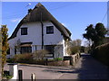
The north end of Ryebridge Lane in Lower Froyle
On the right is the local notice board.
Image: © Shazz
Taken: 19 Mar 2011
0.07 miles
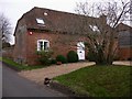
6
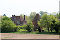
Hodges, Froyle, Hampshire
Grade II* listed.
Image: © Oast House Archive
Taken: 24 Jun 2009
0.11 miles
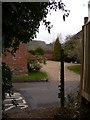
7
Oast at Hodges Farmhouse, Lower Froyle, Hampshire
Image: © Oast House Archive
Taken: 24 Jun 2009
0.13 miles
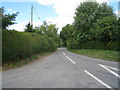
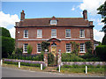
8
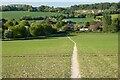
Farmland, Froyle
A footpath descending into the western end of Lower Froyle through a field of linseed.
Image: © Andrew Smith
Taken: 31 May 2021
0.13 miles