IMAGES TAKEN NEAR TO
Farnham Road, ALTON, GU34 4JD
Introduction
This page details the photographs taken nearby to Farnham Road, GU34 4JD by members of the Geograph project.
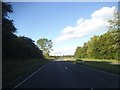
The Geograph project started in 2005 with the aim of publishing, organising and preserving representative images for every square kilometre of Great Britain, Ireland and the Isle of Man.

There are currently over 7.5m images from over14,400 individuals and you can help contribute to the project by visiting https://www.geograph.org.uk
Image Map
Images are licensed for reuse under creativecommons.org/licenses/by-sa/2.0
Notes
- Clicking on the map will re-center to the selected point.
- The higher the marker number, the further away the image location is from the centre of the postcode.
Image Listing (11 Images Found)
Images are licensed for reuse under creativecommons.org/licenses/by-sa/2.0
Image
Details
Distance
2
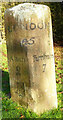
Old Milestone by the track to Bonhams Farm, east of Holybourne
Carved stone post by the UC road (was A31), in parish of ALTON (EAST HAMPSHIRE District), on farm track to Bonhams Farm (road replaced by dual carriageway), set in area of lawn some 300m up farm track on left, on North side of road. Hartford limestone diamond, erected by the Winchester, Upper District (Bagshot to Farnham) turnpike trust in the 19th century.
Re-located from approximately: SU 74646 41612 when the by-pass was built.
Inscription reads:-
: Alton / 2 : : LONDON / 45 : : Farnham / 7 : : Holybourne :
Defaced cut bench mark on left face.
Grade II listed. List Entry Number: 1179944
https://historicengland.org.uk/listing/the-list/list-entry/1179944
Milestone Society National ID: HA_FAAL07.
Image: © K Lawrence
Taken: 8 Feb 2003
0.10 miles
3
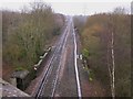
Railway line near Holybourne
This was taken from the A31 bridge over the line and looking towards Farnham which is about seven miles away. A few yards along, the line has a parapet which is where it goes over a minor road called London Road.
Image: © Shazz
Taken: 26 Feb 2011
0.13 miles
4
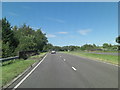
A 31 near Upper Froyle
The slip road here leads to an industrial area.
Image: © Shazz
Taken: 25 Jan 2011
0.16 miles
5
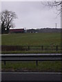
Bonham's Farm viewed from the A31 near Holybourne
Image: © Shazz
Taken: 25 Jan 2011
0.18 miles
6
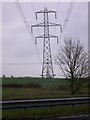
Line of pylons viewed from the A31 near Holybourne
Image: © Shazz
Taken: 25 Jan 2011
0.20 miles
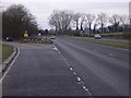
7
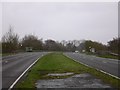
Bus stops on the A31 near Holybourne
Both stops have shelters and a cyclist is at the one on the right.
Image: © Shazz
Taken: 26 Feb 2011
0.21 miles
9
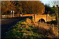
Haw Bridge, Holybourne, Hampshire
The late afternoon winter's sun brings out the colour of the brickwork of this bridge, which appears to have been re-built in recent years.
Image: © Peter Trimming
Taken: 2 Jan 2010
0.23 miles
10
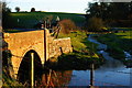
River Wey at Haw Bridge, Holybourne, Hampshire
The River Wey flows from right to left. A small stream flows into the river at this point.
Image: © Peter Trimming
Taken: 2 Jan 2010
0.25 miles