IMAGES TAKEN NEAR TO
Southwood Road, ALTON, GU34 4EB
Introduction
This page details the photographs taken nearby to Southwood Road, GU34 4EB by members of the Geograph project.
The Geograph project started in 2005 with the aim of publishing, organising and preserving representative images for every square kilometre of Great Britain, Ireland and the Isle of Man.

There are currently over 7.5m images from over14,400 individuals and you can help contribute to the project by visiting https://www.geograph.org.uk
Image Map (Loading...)


Getting Data...Please wait
Leaflet Map data © OpenStreetMap
Images are licensed for reuse under creativecommons.org/licenses/by-sa/2.0
Notes
- Clicking on the map will re-center to the selected point.
- The higher the marker number, the further away the image location is from the centre of the postcode.
Image Listing (7 Images Found)
Images are licensed for reuse under creativecommons.org/licenses/by-sa/2.0
Image
Details
Distance
1
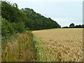
Field edge footpath
Pancake Copse, contiguous with Pancake Plantation, is ahead on the left.
Image: © Robin Webster
Taken: 18 Jul 2015
0.11 miles
2
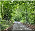
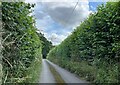
Southwood Road direction B3349
Heading down the hill from Shalden village.
Image: © Mr Ignavy
Taken: 9 Jul 2023
0.12 miles
3
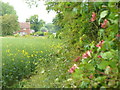
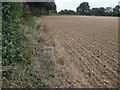
Farming By Shalden
Oilseed rape field close to Southwood Farm. Honeysuckle is in flower by the footpath which runs along the eastern edge of the field.
Image: © Colin Smith
Taken: 28 May 2011
0.13 miles
4
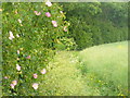
Footpath Near Shalden
Heading south-east, away from Shalden. The path runs between woodland of Pancake Copse and the edge of an oilseed rape field (2011). Wild roses are in bloom.
http://www.british-history.ac.uk/report.aspx?compid=56758
Image: © Colin Smith
Taken: 28 May 2011
0.14 miles
7
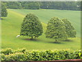
Downland at Shalden
Ornamental trees and grazing on the grassy hillside below the treeline, south of the village of Shalden.
http://www.british-history.ac.uk/report.aspx?compid=56758
Image: © Colin Smith
Taken: 28 May 2011
0.23 miles