IMAGES TAKEN NEAR TO
Thedden, ALTON, GU34 4AT
Introduction
This page details the photographs taken nearby to GU34 4AT by members of the Geograph project.
The Geograph project started in 2005 with the aim of publishing, organising and preserving representative images for every square kilometre of Great Britain, Ireland and the Isle of Man.

There are currently over 7.5m images from over14,400 individuals and you can help contribute to the project by visiting https://www.geograph.org.uk
Image Map (Loading...)


Getting Data...Please wait
Leaflet Map data © OpenStreetMap
Images are licensed for reuse under creativecommons.org/licenses/by-sa/2.0
Notes
- Clicking on the map will re-center to the selected point.
- The higher the marker number, the further away the image location is from the centre of the postcode.
Image Listing (5 Images Found)
Images are licensed for reuse under creativecommons.org/licenses/by-sa/2.0
Image
Details
Distance
1
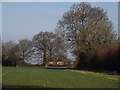
Downland Near Beech
Grassy fields, hedgerows and patches of woodland interspersed with cottages and farms on the Hampshire downs west of Alton.
Image: © Colin Smith
Taken: 1 Feb 2012
0.08 miles
2
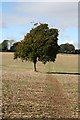
Field tree near Thedden Farm (1)
Field tree on public footpath Bentworth 18 between Thedden Farm and Tinker's Lane, seen also from the opposite direction: Image
Image: © Hugh Craddock
Taken: 13 Oct 2012
0.14 miles
3
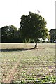
Field tree near Thedden Farm (2)
Field tree on public footpath Bentworth 18 between Thedden Farm and Tinker's Lane, seen also from the opposite direction: Image
Image: © Hugh Craddock
Taken: 13 Oct 2012
0.14 miles
4
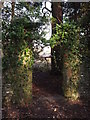
Thedden Grange
Ivy-covered brick gateway on Wivelrod Road, north of Beech. It is in a flint estate wall lining the road.
Image: © Colin Smith
Taken: 1 Feb 2012
0.15 miles
5
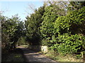
Wivelrod Road
Country lane passing the flint wall of the Thedden Grange estate.
Image: © Colin Smith
Taken: 1 Feb 2012
0.20 miles