IMAGES TAKEN NEAR TO
Selborne Road, ALTON, GU34 3NB
Introduction
This page details the photographs taken nearby to Selborne Road, GU34 3NB by members of the Geograph project.
The Geograph project started in 2005 with the aim of publishing, organising and preserving representative images for every square kilometre of Great Britain, Ireland and the Isle of Man.

There are currently over 7.5m images from over14,400 individuals and you can help contribute to the project by visiting https://www.geograph.org.uk
Image Map
Images are licensed for reuse under creativecommons.org/licenses/by-sa/2.0
Notes
- Clicking on the map will re-center to the selected point.
- The higher the marker number, the further away the image location is from the centre of the postcode.
Image Listing (21 Images Found)
Images are licensed for reuse under creativecommons.org/licenses/by-sa/2.0
Image
Details
Distance
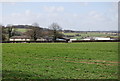
2
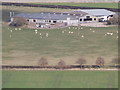
Norton Farm
Barns with sheep grazing in the field - seen from Bush Down.
Image: © Colin Smith
Taken: 10 Mar 2012
0.03 miles
6
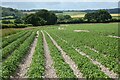
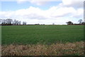
Farmland, Worldham
Potatoes occupied fields to the north and south of Hartley Park Farm.
Image: © Andrew Smith
Taken: 11 Jun 2022
0.12 miles
10
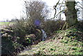
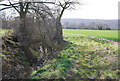
Small stream in a ditch near Norton Farm, Selborne
Image: © N Chadwick
Taken: 8 Mar 2009
0.15 miles