IMAGES TAKEN NEAR TO
Sotherington Lane, ALTON, GU34 3LS
Introduction
This page details the photographs taken nearby to Sotherington Lane, GU34 3LS by members of the Geograph project.
The Geograph project started in 2005 with the aim of publishing, organising and preserving representative images for every square kilometre of Great Britain, Ireland and the Isle of Man.

There are currently over 7.5m images from over14,400 individuals and you can help contribute to the project by visiting https://www.geograph.org.uk
Image Map
Images are licensed for reuse under creativecommons.org/licenses/by-sa/2.0
Notes
- Clicking on the map will re-center to the selected point.
- The higher the marker number, the further away the image location is from the centre of the postcode.
Image Listing (10 Images Found)
Images are licensed for reuse under creativecommons.org/licenses/by-sa/2.0
Image
Details
Distance
8
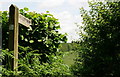
Fingerpost by Smoky House
Snap Wood visible in the distance.
Image: © Hugh Chevallier
Taken: 17 Jun 2012
0.21 miles
9
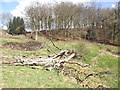
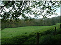
Dry Valley Below Cornbrooks Hanger
At the head of the dry valley with a fallen tree in the foreground and beech hanger in the background.
Image: © Colin Smith
Taken: 6 Mar 2012
0.23 miles
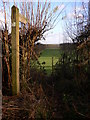
10
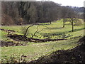
Cornbrooks Hanger
Dry grassy valley, with fallen tree, below the beeches of Cornbrooks Hanger.
Image: © Colin Smith
Taken: 6 Mar 2012
0.24 miles