IMAGES TAKEN NEAR TO
High Street, ALTON, GU34 3JU
Introduction
This page details the photographs taken nearby to High Street, GU34 3JU by members of the Geograph project.
The Geograph project started in 2005 with the aim of publishing, organising and preserving representative images for every square kilometre of Great Britain, Ireland and the Isle of Man.

There are currently over 7.5m images from over14,400 individuals and you can help contribute to the project by visiting https://www.geograph.org.uk
Image Map (Loading...)


Getting Data...Please wait
Leaflet Map data © OpenStreetMap
Images are licensed for reuse under creativecommons.org/licenses/by-sa/2.0
Notes
- Clicking on the map will re-center to the selected point.
- The higher the marker number, the further away the image location is from the centre of the postcode.
Image Listing (400 Images Found)
Images are licensed for reuse under creativecommons.org/licenses/by-sa/2.0
Image
Details
Distance
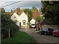
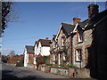
1
Houses in Selborne
Chalk is much used as a building material in the village and the surrounding area.
Image: © Stefan Czapski
Taken: 8 Jul 2017
0.01 miles
4
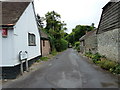
Looking from Selborne High Street into Huckers Lane
Image: © Basher Eyre
Taken: 31 Jul 2010
0.01 miles
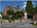
5
Cottages in Selborne
The village street runs N-S along the downland valley bottom.
Image: © Colin Smith
Taken: 6 Mar 2012
0.01 miles
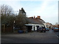
6
Looking from the car park at Selborne Common onto the B3006
Image: © Basher Eyre
Taken: 17 Jan 2012
0.02 miles
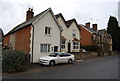
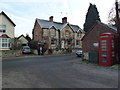
8
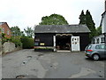
Selborne Exotic Woodcraft next to "The Queens"
Image: © Basher Eyre
Taken: 31 Jul 2010
0.02 miles
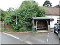
9
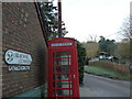
Phone box at the bottom of Selborne Common
Image: © Basher Eyre
Taken: 17 Jan 2012
0.02 miles