IMAGES TAKEN NEAR TO
The Old Station Yard, Gosport Road, ALTON, GU34 3DD
Introduction
This page details the photographs taken nearby to The Old Station Yard, Gosport Road, GU34 3DD by members of the Geograph project.
The Geograph project started in 2005 with the aim of publishing, organising and preserving representative images for every square kilometre of Great Britain, Ireland and the Isle of Man.

There are currently over 7.5m images from over14,400 individuals and you can help contribute to the project by visiting https://www.geograph.org.uk
Image Map (Loading...)


Getting Data...Please wait
Leaflet Map data © OpenStreetMap
Images are licensed for reuse under creativecommons.org/licenses/by-sa/2.0
Notes
- Clicking on the map will re-center to the selected point.
- The higher the marker number, the further away the image location is from the centre of the postcode.
Image Listing (50 Images Found)
Images are licensed for reuse under creativecommons.org/licenses/by-sa/2.0
Image
Details
Distance
1
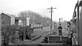
Farringdon Halt, on the Last Day of the Meon Valley Branch
View SE from an Alton - Fareham train on February 5 1955 - the last day of the passenger service; goods continued Alton - Farringdon until 5/8/68. [Regrettably, not a good photograph - but it was a dull and cold February morning].
Image: © Ben Brooksbank
Taken: 5 Feb 1955
0.05 miles
2
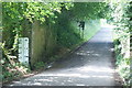
Brightstone Lane, Lower Farringdon, Hampshire
The railway bridge is long gone, but there is still a significant dip where the lane was lowered to pass under the bridge. As can be seen from the sign, floods can occur.
The Meon Valley Railway crossed the lane at this point.
http://en.wikipedia.org/wiki/Meon_Valley_Railway#Background
Image: © Peter Trimming
Taken: 25 Jul 2009
0.07 miles

5
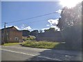
Cottage on Brightstone Lane, Farringdon
The road climbs towards Four Marks from the crossroads in Lower Farringdon.
Image: © Andrew Smith
Taken: 27 Sep 2009
0.08 miles
6
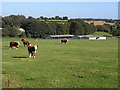
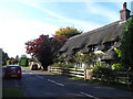
Pasture, Farringdon
Cattle and buildings at Ivy Farm at the southern end of Lower Farringdon.
Image: © Andrew Smith
Taken: 27 Sep 2009
0.09 miles
7
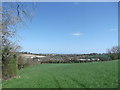
Towards Farringdon
Taken on the footpath running parallel with Brightstone Lane, looking East back towards Farringdon.
Image: © easthantsxc
Taken: 13 Apr 2014
0.09 miles

9
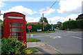
Telephone box and junction with the A32, Lower Farringdon
The telephone box is no longer in use as a telephone box. To see what's inside see Image .
Image: © Barry Shimmon
Taken: 31 Jul 2015
0.10 miles
10

Gosport Road at the junction of Brightstone Lane
Image: © David Howard
Taken: 3 Jul 2016
0.10 miles