IMAGES TAKEN NEAR TO
Honey Lane, ALTON, GU34 3BZ
Introduction
This page details the photographs taken nearby to Honey Lane, GU34 3BZ by members of the Geograph project.
The Geograph project started in 2005 with the aim of publishing, organising and preserving representative images for every square kilometre of Great Britain, Ireland and the Isle of Man.

There are currently over 7.5m images from over14,400 individuals and you can help contribute to the project by visiting https://www.geograph.org.uk
Image Map
Images are licensed for reuse under creativecommons.org/licenses/by-sa/2.0
Notes
- Clicking on the map will re-center to the selected point.
- The higher the marker number, the further away the image location is from the centre of the postcode.
Image Listing (91 Images Found)
Images are licensed for reuse under creativecommons.org/licenses/by-sa/2.0
Image
Details
Distance
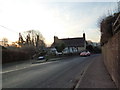
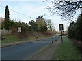
1

Approaching the junction of the B3006 with Honey Lane
Image: © Basher Eyre
Taken: 17 Jan 2012
0.04 miles
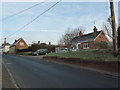
5
Southern end of Selborne
By the junction with Honey Lane.
Image: © Robin Webster
Taken: 13 Nov 2013
0.06 miles
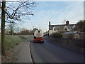
6
20mph sign approaching Selborne village
Image: © Basher Eyre
Taken: 17 Jan 2012
0.06 miles
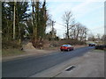
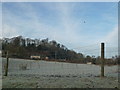
9
Tanker passing through Selborne on the B3006
Image: © Basher Eyre
Taken: 17 Jan 2012
0.08 miles
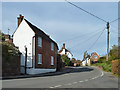
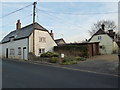
10
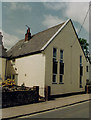
Former Selborne Congregational Chapel
Erected in 1860. Now converted into a private residence.
Image: © Michael FORD
Taken: Unknown
0.08 miles