IMAGES TAKEN NEAR TO
Salisbury Close, ALTON, GU34 2TP
Introduction
This page details the photographs taken nearby to Salisbury Close, GU34 2TP by members of the Geograph project.
The Geograph project started in 2005 with the aim of publishing, organising and preserving representative images for every square kilometre of Great Britain, Ireland and the Isle of Man.

There are currently over 7.5m images from over14,400 individuals and you can help contribute to the project by visiting https://www.geograph.org.uk
Image Map (Loading...)


Getting Data...Please wait
Leaflet Map data © OpenStreetMap
Images are licensed for reuse under creativecommons.org/licenses/by-sa/2.0
Notes
- Clicking on the map will re-center to the selected point.
- The higher the marker number, the further away the image location is from the centre of the postcode.
Image Listing (9 Images Found)
Images are licensed for reuse under creativecommons.org/licenses/by-sa/2.0
Image
Details
Distance
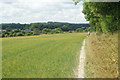
7
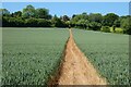
In the Corner of the Field, Alton, Hampshire
The trees form a boundary on two sides of this wheat field. In the corner of the field, in the shade, is a deer.
Image: © Peter Trimming
Taken: 25 Jul 2009
0.22 miles
8
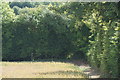
Weekend Leisure
Walkers enjoying a downland stroll south of Alton - passing between a bean field and a hedgerow.
Image: © Colin Smith
Taken: 3 Sep 2011
0.22 miles
9
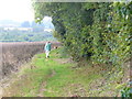
Footpath Beside the Meadow, Alton, Hampshire
A lady walks her dog along the path. In the next field, they will see a deer.
Image: © Peter Trimming
Taken: 25 Jul 2009
0.24 miles