IMAGES TAKEN NEAR TO
Ascot Close, ALTON, GU34 2TE
Introduction
This page details the photographs taken nearby to Ascot Close, GU34 2TE by members of the Geograph project.
The Geograph project started in 2005 with the aim of publishing, organising and preserving representative images for every square kilometre of Great Britain, Ireland and the Isle of Man.

There are currently over 7.5m images from over14,400 individuals and you can help contribute to the project by visiting https://www.geograph.org.uk
Image Map (Loading...)


Getting Data...Please wait
Leaflet Map data © OpenStreetMap
Images are licensed for reuse under creativecommons.org/licenses/by-sa/2.0
Notes
- Clicking on the map will re-center to the selected point.
- The higher the marker number, the further away the image location is from the centre of the postcode.
Image Listing (13 Images Found)
Images are licensed for reuse under creativecommons.org/licenses/by-sa/2.0
Image
Details
Distance
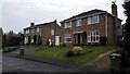
1
Signal AT54, Mid Hants Railway
Most of the signals on this heritage line are semaphore, but a few are colour-light.
Image: © Robin Webster
Taken: 9 Jul 2013
0.14 miles
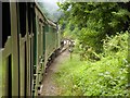
2

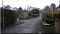
The Watercress Line Approaching Mount Pleasant Road Bridge
Image: © David Dixon
Taken: 19 Jul 2014
0.15 miles
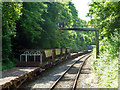
3
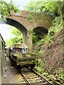
The Mid-Hants Railway, Mount Pleasant Road Bridge
Image: © David Dixon
Taken: 19 Jul 2014
0.17 miles
4
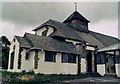
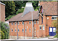
Former St Mary's Home Chapel, Alton
Grade 2 listed building erected in 1913. Now used as a commercial establishment under the name Bell House Chapel.
Image: © Michael FORD
Taken: Unknown
0.17 miles
6
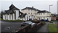
Church and Offices on Turk Street and St Mary's Close - Alton
Image: © James Emmans
Taken: 11 Apr 2016
0.18 miles
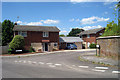
8
Former Maltings, Lower Turk Street, Alton
Image: © Pierre Terre
Taken: 29 Aug 2008
0.19 miles