IMAGES TAKEN NEAR TO
The Omni Business Centre, Omega Park, ALTON, GU34 2QD
Introduction
This page details the photographs taken nearby to The Omni Business Centre, Omega Park, GU34 2QD by members of the Geograph project.
The Geograph project started in 2005 with the aim of publishing, organising and preserving representative images for every square kilometre of Great Britain, Ireland and the Isle of Man.

There are currently over 7.5m images from over14,400 individuals and you can help contribute to the project by visiting https://www.geograph.org.uk
Image Map (Loading...)


Getting Data...Please wait
Leaflet Map data © OpenStreetMap
Images are licensed for reuse under creativecommons.org/licenses/by-sa/2.0
Notes
- Clicking on the map will re-center to the selected point.
- The higher the marker number, the further away the image location is from the centre of the postcode.
Image Listing (8 Images Found)
Images are licensed for reuse under creativecommons.org/licenses/by-sa/2.0
Image
Details
Distance
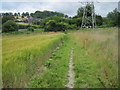
2
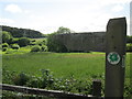
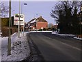
Hangers Way sign, Alton
The Hangers Way takes its name from the old English word “hangra” which means wooded slope.
Image: © Peter S
Taken: 6 Jun 2015
0.14 miles
4
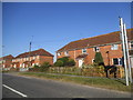
The east end of Ashdell Road in Alton
At the end is Wilsom Road (B3004).
Image: © Shazz
Taken: 26 Dec 2010
0.19 miles
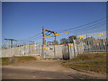
6
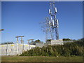
Communication tower on Mill Road, Alton
This is set up on a pylon leaving the substation on the left
Image: © David Howard
Taken: 14 Aug 2016
0.23 miles
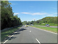
7
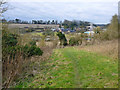
Footpath towards Alton
Used by the 'Hangers Way' route. The dual carriageway A31 has to crossed on the level at the bottom of the hill.
Image: © Robin Webster
Taken: 26 Feb 2016
0.24 miles