IMAGES TAKEN NEAR TO
Vicarage Hill, ALTON, GU34 2BF
Introduction
This page details the photographs taken nearby to Vicarage Hill, GU34 2BF by members of the Geograph project.
The Geograph project started in 2005 with the aim of publishing, organising and preserving representative images for every square kilometre of Great Britain, Ireland and the Isle of Man.

There are currently over 7.5m images from over14,400 individuals and you can help contribute to the project by visiting https://www.geograph.org.uk
Image Map
Images are licensed for reuse under creativecommons.org/licenses/by-sa/2.0
Notes
- Clicking on the map will re-center to the selected point.
- The higher the marker number, the further away the image location is from the centre of the postcode.
Image Listing (390 Images Found)
Images are licensed for reuse under creativecommons.org/licenses/by-sa/2.0
Image
Details
Distance
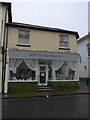
1
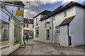
Butties Alley to Market Street
The alley between the Vicarage Hill Car Park and Market Street.
Image: © HackBitz
Taken: 1 Mar 2008
0.01 miles
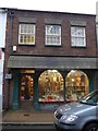
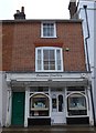
2
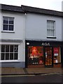
Aga, Market Street
How did that shop come to be situated here? Now that's a saga!
Image: © Basher Eyre
Taken: 3 Jan 2015
0.01 miles
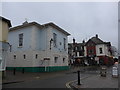
3
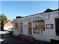
2016: a year on Geograph (Day 279)
Curiously this restaurant is right in the middle of a car park
Image: © Basher Eyre
Taken: 5 Oct 2016
0.02 miles
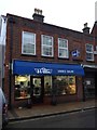
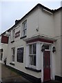
10
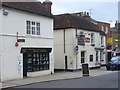
Market Street, Alton
The Alton Cobbler and The King's Head, cheek by jowl, in the centre of the Georgian town of Alton.
Image: © Colin Smith
Taken: 28 May 2011
0.02 miles