IMAGES TAKEN NEAR TO
Kipling Road, ALTON, GU34 1UD
Introduction
This page details the photographs taken nearby to Kipling Road, GU34 1UD by members of the Geograph project.
The Geograph project started in 2005 with the aim of publishing, organising and preserving representative images for every square kilometre of Great Britain, Ireland and the Isle of Man.

There are currently over 7.5m images from over14,400 individuals and you can help contribute to the project by visiting https://www.geograph.org.uk
Image Map
Images are licensed for reuse under creativecommons.org/licenses/by-sa/2.0
Notes
- Clicking on the map will re-center to the selected point.
- The higher the marker number, the further away the image location is from the centre of the postcode.
Image Listing (8 Images Found)
Images are licensed for reuse under creativecommons.org/licenses/by-sa/2.0
Image
Details
Distance
1
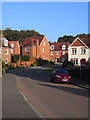
Connaught Way, Alton
A new development in a turning on the northern side of Chawton Park Road.
Image: © Andrew Smith
Taken: 27 Sep 2009
0.03 miles
2
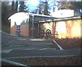
Chawton Park Surgery
This is built on the site of the coal siding for Lord Mayor Treloar's Hospital. A once famous Orthopaedic hospital now closed and demolished.
Image: © Graham Clutton
Taken: 25 Dec 2005
0.06 miles
3
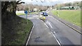
Roundabout opposite Alton Community Hospital
Image: © James Emmans
Taken: 11 Apr 2016
0.09 miles
4
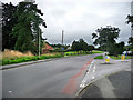
Chawton Park Road, Alton
Just by the entrance to Alton Community Hospital
Image: © Chris Gunns
Taken: 12 Aug 2009
0.14 miles
5
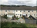
Terraced houses between Alton Sports Centre and the Mid Hants Railway
Image: © David Robinson
Taken: 10 Sep 2022
0.19 miles
6
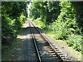
Mid Hants Railway at 50-1/2 mile post
The mileage is measured from Waterloo via a rather indirect route involving reversal at Guildford.
Image: © Robin Webster
Taken: 9 Jul 2013
0.19 miles
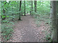
8
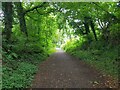
Alton: The Writers' Way
The Writers' Way is a 13 mile trail between Chawton (Jane Austen) and Selborne (Gilbert White) through Alton. This section follows Mounter's Lane, on the southern outskirts of Alton, on the approach to Mounter's Bridge.
Image: © Nigel Cox
Taken: 3 Jul 2021
0.21 miles