IMAGES TAKEN NEAR TO
Whitedown Lane, ALTON, GU34 1QR
Introduction
This page details the photographs taken nearby to Whitedown Lane, GU34 1QR by members of the Geograph project.
The Geograph project started in 2005 with the aim of publishing, organising and preserving representative images for every square kilometre of Great Britain, Ireland and the Isle of Man.

There are currently over 7.5m images from over14,400 individuals and you can help contribute to the project by visiting https://www.geograph.org.uk
Image Map
Images are licensed for reuse under creativecommons.org/licenses/by-sa/2.0
Notes
- Clicking on the map will re-center to the selected point.
- The higher the marker number, the further away the image location is from the centre of the postcode.
Image Listing (43 Images Found)
Images are licensed for reuse under creativecommons.org/licenses/by-sa/2.0
Image
Details
Distance
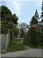
1
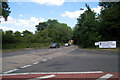
Whitedown Lane (The Annexe), Alton
The road built to cut to the A31 kept the name of the original road which is alongside it to the left, hence The Annexe is used to designate which is which.
Image: © David Howard
Taken: 21 May 2012
0.04 miles
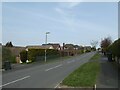
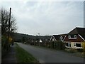
2
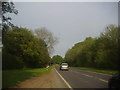
Spring forward, fall back (78)
Looking from Highridge into Whitedown Lane
Image: © Basher Eyre
Taken: 28 Mar 2022
0.06 miles
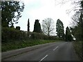
4
Spring forward, fall back (79)
Looking north-east along Highridge
Image: © Basher Eyre
Taken: 28 Mar 2022
0.06 miles
5
Spring forward, fall back (77)
Footpath from Highridge to Ackender Wood
Image: © Basher Eyre
Taken: 28 Mar 2022
0.06 miles
6
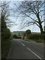
Spring forward, fall back (76)
Looking north-west in Highridge
Image: © Basher Eyre
Taken: 28 Mar 2022
0.08 miles
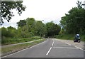
8
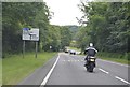
Spring forward, fall back (80)
Looking south-west along Highridge
Image: © Basher Eyre
Taken: 28 Mar 2022
0.10 miles
9
Spring forward, fall back (75)
Looking south-east in Highridge
Image: © Basher Eyre
Taken: 28 Mar 2022
0.10 miles