IMAGES TAKEN NEAR TO
Tower Street, ALTON, GU34 1NS
Introduction
This page details the photographs taken nearby to Tower Street, GU34 1NS by members of the Geograph project.
The Geograph project started in 2005 with the aim of publishing, organising and preserving representative images for every square kilometre of Great Britain, Ireland and the Isle of Man.

There are currently over 7.5m images from over14,400 individuals and you can help contribute to the project by visiting https://www.geograph.org.uk
Image Map (Loading...)


Getting Data...Please wait
Leaflet Map data © OpenStreetMap
Images are licensed for reuse under creativecommons.org/licenses/by-sa/2.0
Notes
- Clicking on the map will re-center to the selected point.
- The higher the marker number, the further away the image location is from the centre of the postcode.
Image Listing (153 Images Found)
Images are licensed for reuse under creativecommons.org/licenses/by-sa/2.0
Image
Details
Distance

2
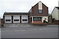
Alton fire station
Alton fire station, The Butts, Alton, Hampshire
Image: © Kevin Hale
Taken: 11 Nov 2006
0.05 miles
3
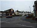
Looking from Queens Road into Butts Road
Image: © Basher Eyre
Taken: 13 Nov 2010
0.06 miles
4
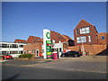
BP petrol station on Butts Road, Alton
Image: © David Howard
Taken: 14 Aug 2016
0.06 miles
5
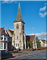
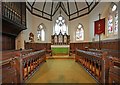
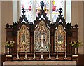
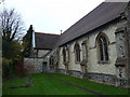
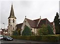
All Saints Church, Alton
Grade II listed church built in the 1870s by architect Frederick Charles Dyer. Later additions. Description at this https://historicengland.org.uk/listing/the-list/list-entry/1391647.
Image: © Jim Osley
Taken: 17 Feb 2018
0.06 miles