IMAGES TAKEN NEAR TO
Whitedown, ALTON, GU34 1LX
Introduction
This page details the photographs taken nearby to Whitedown, GU34 1LX by members of the Geograph project.
The Geograph project started in 2005 with the aim of publishing, organising and preserving representative images for every square kilometre of Great Britain, Ireland and the Isle of Man.

There are currently over 7.5m images from over14,400 individuals and you can help contribute to the project by visiting https://www.geograph.org.uk
Image Map (Loading...)


Getting Data...Please wait
Leaflet Map data © OpenStreetMap
Images are licensed for reuse under creativecommons.org/licenses/by-sa/2.0
Notes
- Clicking on the map will re-center to the selected point.
- The higher the marker number, the further away the image location is from the centre of the postcode.
Image Listing (171 Images Found)
Images are licensed for reuse under creativecommons.org/licenses/by-sa/2.0
Image
Details
Distance
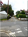
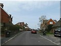
1
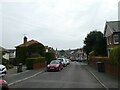
Spring forward, fall back (55)
Looking south-east along Queens Road
Image: © Basher Eyre
Taken: 28 Mar 2022
0.04 miles
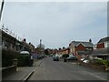
3
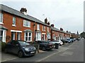
Spring forward, fall back (54)
Houses in Queens Road
Image: © Basher Eyre
Taken: 28 Mar 2022
0.04 miles
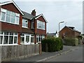
4
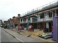
Spring forward, fall back (53)
New build in Queens Road
Image: © Basher Eyre
Taken: 28 Mar 2022
0.04 miles
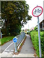
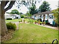
5
Looking across Queens Road on Rack Close Road
Image: © Shazz
Taken: 16 Aug 2014
0.05 miles
6
Spring forward, fall back (52)
Looking north-west up Queen's Road
Image: © Basher Eyre
Taken: 28 Mar 2022
0.06 miles
8
Spring forward, fall back (51)
Approaching the junction of Queens Road and Rack Close Road
Image: © Basher Eyre
Taken: 28 Mar 2022
0.07 miles
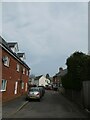
9
Spring forward, fall back (56)
Queens Road
Image: © Basher Eyre
Taken: 28 Mar 2022
0.07 miles
10
Spring forward, fall back (50)
Looking north-east in Rack Close Road
Image: © Basher Eyre
Taken: 28 Mar 2022
0.08 miles