IMAGES TAKEN NEAR TO
Minchin Lane, ALTON, GU34 1GW
Introduction
This page details the photographs taken nearby to Minchin Lane, GU34 1GW by members of the Geograph project.
The Geograph project started in 2005 with the aim of publishing, organising and preserving representative images for every square kilometre of Great Britain, Ireland and the Isle of Man.

There are currently over 7.5m images from over14,400 individuals and you can help contribute to the project by visiting https://www.geograph.org.uk
Image Map (Loading...)


Getting Data...Please wait
Leaflet Map data © OpenStreetMap
Images are licensed for reuse under creativecommons.org/licenses/by-sa/2.0
Notes
- Clicking on the map will re-center to the selected point.
- The higher the marker number, the further away the image location is from the centre of the postcode.
Image Listing (6 Images Found)
Images are licensed for reuse under creativecommons.org/licenses/by-sa/2.0
Image
Details
Distance
2
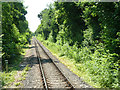
Mid Hants Railway at 50-3/4 mile post
The mileage is measured from Waterloo via a rather indirect route involving reversal at Guildford.
Image: © Robin Webster
Taken: 9 Jul 2013
0.16 miles
3
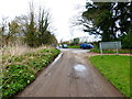
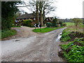
Junction of Chawton Park Road and Northfield Lane
Image: © Shazz
Taken: 24 Mar 2014
0.16 miles
6
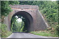
Bridge Over Northfield Lane, Chawton, Hampshire
The Mid Hants Railway passes over this bridge.
http://www.watercressline.co.uk/
Image: © Peter Trimming
Taken: 25 Jul 2009
0.24 miles