IMAGES TAKEN NEAR TO
Hill Brow, LISS, GU33 7NW
Introduction
This page details the photographs taken nearby to GU33 7NW by members of the Geograph project.
The Geograph project started in 2005 with the aim of publishing, organising and preserving representative images for every square kilometre of Great Britain, Ireland and the Isle of Man.

There are currently over 7.5m images from over14,400 individuals and you can help contribute to the project by visiting https://www.geograph.org.uk
Image Map
Images are licensed for reuse under creativecommons.org/licenses/by-sa/2.0
Notes
- Clicking on the map will re-center to the selected point.
- The higher the marker number, the further away the image location is from the centre of the postcode.
Image Listing (23 Images Found)
Images are licensed for reuse under creativecommons.org/licenses/by-sa/2.0
Image
Details
Distance
7
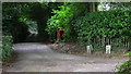
Huntsbottom Lane
This lane is a byway. Plantation Road is on the right and London Road (B2070) is where the byway ends at the top of the picture. Somewhere near the postbox is the county border between Hampshire and West Sussex. The camera is in Hampshire.
Image: © Shazz
Taken: 10 Aug 2009
0.16 miles
8
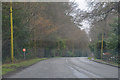
Hill Brow : London Road B2070
A road heading into Hill Brow.
Image: © Lewis Clarke
Taken: 29 Mar 2018
0.17 miles
9
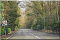
Hill Brow : London Road B2070
Looking at a road heading through the hamlet of Hill Brow.
Image: © Lewis Clarke
Taken: 28 Mar 2018
0.17 miles
10
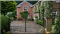
The Mews on Huntsbottom Lane
This is in Hampshire.
Image: © Shazz
Taken: 10 Aug 2009
0.18 miles